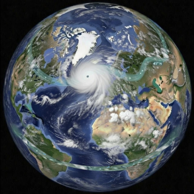
The jet stream is deforming mainly due to Arctic amplification: the Arctic is warming nearly four times faster than the global average, reducing the temperature contrast with mid-latitudes and weakening the jet stream's engine. Weaker, it becomes more wavy, and its meanders (Rossby waves) stall, creating persistent atmospheric blocks. These blocks are responsible for extreme weather events such as heatwaves in Europe (2019, 2023), devastating floods (Germany 2021, Pakistan 2022), or intense cold spells (Texas 2021).
The jet stream is a fast-moving air current (150 to 320 km/h, with exceptions) circulating at high altitude (8 to 12 kilometers) around the Northern Hemisphere. It is a true boundary created by the thermal contrast between cold polar air and warm subtropical air. This flow is a powerful engine of the climate system. Its position and strength directly influence the trajectory of depressions and surface temperature distribution. However, since the early 21st century, scientists have observed increasingly erratic behavior.
It does not follow a perfectly zonal (parallel to the equator) straight line. It forms meanders (waves) called Rossby waves (planetary waves) that snake southward (troughs) and northward (ridges).
With fewer continental landmasses to disrupt its flow, the Southern Hemisphere jet stream is often stronger, more regular, and more linear than its northern counterpart. It swirls around Antarctica and helps isolate the frozen continent.
The primary cause of this disruption is the rapid amplification of climate warming in the Arctic. This region is warming nearly four times faster than the global average, a phenomenon climatologists call Arctic amplification. By reducing the thermal contrast between the North Pole and mid-latitudes, the very engine of the jet stream is weakened. Less powerful, it becomes more sinuous, and its meanders tend to stagnate.
Far from being a single wave, the jet stream resembles an atmospheric channel where multiple undulations coexist and evolve independently. These meanders can occasionally synchronize their phases and combine with other Rossby waves. The speed of the jet sometimes determines the appearance of quasi-stationary resonances, freezing these wave patterns. It is this dynamic synchronization that transforms a normal fluctuation into a lasting weather event.
This slowdown has a major consequence: weather systems (high-pressure or low-pressure) remain blocked over the same regions for longer. This explains the persistence of certain extreme events, such as the historic heatwave in Europe in 2019 or the devastating floods in Germany in 2021. As climatologist Michael E. Mann (b. 1965) explains, these atmospheric blocking situations are reinforced by a resonance phenomenon of planetary waves: the jet stream's meanders align, slow their propagation, and lead to an abnormal persistence of weather patterns.
The influence of a disrupted jet stream is not limited to a few heatwaves or intense rainfalls. It manifests as a cascade of effects across the entire Northern Hemisphere.
| Event | Year | Region | Jet Stream Mechanism Involved |
|---|---|---|---|
| Russian heatwave and fires | 2010 | Western Russia | Blocking of a high-pressure system by a persistent meander (stationary Rossby waves) |
| Floods in Pakistan | 2010 / 2022 | South Asia | Interaction between an abnormally sinuous jet and the monsoon |
| Drought and fires in California | 2012-2015 | Western United States | Persistent anticyclonic ridge ("Ridiculously Resilient Ridge") blocking precipitation |
| Floods in Germany and Belgium | 2021 | Western Europe | Omega block trapping rainy depressions for several days |
| "Texas Freeze" cold wave | 2021 | Southern United States | Deep plunge of the polar vortex due to jet stream weakening |
| Heat dome in Canada | 2021 | British Columbia | Omega block creating extreme adiabatic compression (49.6°C in Lytton) |
| Historic drought in Europe | 2022 | Western and Central Europe | Subtropical high-pressure system moving abnormally northward with weakened jet |
| Multiple heatwaves in Europe | 2023 | Mediterranean Basin | Successive heat waves linked to amplified jet stream meanders |
| Storm Boris | 2024 | Central Europe | Omega block trapping a depression with torrential rainfall |
| Cold wave in North America | 2024 | United States and Canada | Polar vortex descent to subtropical latitudes |
Source: NOAA Climate.gov, World Weather Attribution, and World Meteorological Organization.
The jet stream is a fast-flowing air current at high altitude (between 8 and 12 km), with typical speeds of 150 to 320 km/h. It is generated by the temperature contrast between cold polar air and warm subtropical air. It is a true "atmospheric highway" that directly influences the path of storms and the distribution of surface temperatures.
The main cause is Arctic amplification: the Arctic is warming nearly four times faster than the global average. This reduces the temperature contrast between the North Pole and mid-latitudes, thereby weakening the jet stream's engine. A weaker jet stream meanders more, and its meanders (Rossby waves) tend to stall or become blocked.
When the jet stream slows down and forms amplified meanders, these can synchronize to create persistent atmospheric blocks (such as an omega block). These blocks freeze weather systems (highs or lows) over the same regions for days or weeks, causing unusually long and intense heatwaves, droughts, floods, or cold spells.
 The Principle of Least Action: Why Does Nature Always Choose the Most Economical Path?
  Evolutionary Convergence: Chance, Necessity… or Mirage?
  The Five Mass Extinctions: What do these planetary catastrophes reveal?
  Cryosphere: when the ice giants still protect us
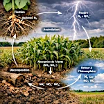 The Nitrogen Cycle: From Air to Life
  The Jet Stream: When the Atmospheric River Overflows Its Banks
 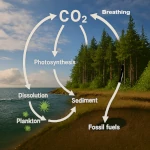 The Carbon Cycle: The Harmonious Interaction of Oceans, Forests, and Subsoils
  The Water Paradox: Without it, no life
 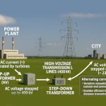 Why 220V Alternating Current is in Our Outlets: A Matter of Physics
  The Last Glacial Shock: The Younger Dryas and Its Impact on Prehistoric Societies
  536: The Year Without a Summer and the Beginning of the Late Antique Little Ice Age
 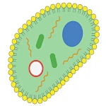 The Minimal Cell: The Inevitable Emergence
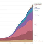 Evolution of Global Energy Consumption: From Steam Engines to Digital Servers
 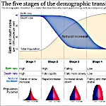 The Demographic Transition: Growth or Decline?
 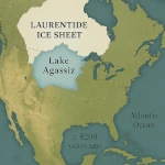 Lake Agassiz: A Deluge that Changed the Climate
 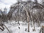 Drunken Forests: Understanding the Phenomenon of Permafrost Thaw
  There is Electricity in the Air!
  Why Doesn't CO2 Fall to the Ground?
 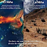 El Niño and La Niña: The Two Breaths of the Pacific That Shape Global Climate
  Endangered Species: Dynamics of Extinction
  The Toxic Legacy of Acid Rain
  Global Warming in Figures: What the Scientific Data Says
  What is Sustainable Development?
  The Aral Sea: A Lesson for Humanity
 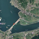 Three Gorges Dam: Impacts on Ecosystems
 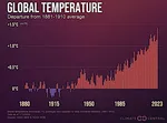 The Hottest Years Since Records Began
 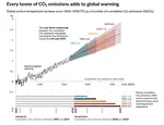 Magnitude of future global warming
 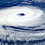 Earth in Crisis: Collapse or Renaissance?
 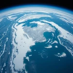 Ice on the Brink: The Inevitable Decline of Arctic Sea Ice
  Earth's Water Reservoirs: From Oceans to Groundwater
 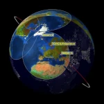 Sea Levels Are Rising, But How Fast?
  The Other Climate Threat: Earth Shrouded in Shadow and Humidity
  The Age of the Sahara: From Green Prairie to Stone Desert
 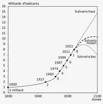 World Population from 1800 to 2100
  Oil: The Fall of a Giant in the Era of Renewable Energy
  Kamchatka King Crab: A Giant of the Oceans
  The collapse of a society
  Slight Progress in the Global Ecological Footprint
 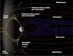 The South Atlantic Anomaly
  The phenomenon of soil sinking is called subsidence
 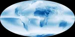 Why Is Earth So Often Cloudy?
  The Planet's New Clouds
 Desertec: A Solar Dream for Europe and Africa