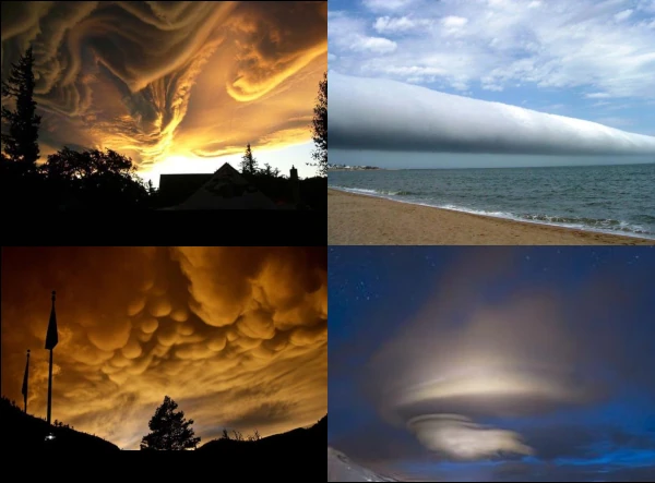
Earth's atmosphere contains spectacular cloud phenomena that sometimes defy traditional classifications. Among these remarkable formations, three types are particularly impressive and have captured the attention of meteorologists and the public: Asperatus clouds, with chaotic undulations resembling a rough sea; Mammatus, with their characteristic pouch-like structures hanging like clusters; and Morning Glory, a rare formation in the shape of elongated rolls. Although rare, these phenomena offer valuable insights into atmospheric dynamics and cloud formation processes.
| Cloud type | Typical altitude | Formation conditions | Rarity | Observation regions |
|---|---|---|---|---|
| Asperatus (Undulatus asperatus) | 2,000 - 4,000 m | Atmospheric instability, wind shear | Rare | Worldwide (plains and plateaus) |
| Mammatus (Mamma) | Base at 2,000 - 6,000 m | Thunderstorms, turbulence, temperature inversion | Fairly common with thunderstorms | Worldwide |
| Morning Glory | 100 - 300 m | Gravity waves, specific sea breezes | Extremely rare | Gulf of Carpentaria (Australia) |
| Noctilucent (Polar mesospheric clouds) | 76 - 85 km | Very cold mesosphere, meteoric water vapor | Rare (high latitudes) | Polar regions in summer |
| Kelvin-Helmholtz (Fluctus) | Variable | Significant wind shear between two layers | Rare | Worldwide |
| Pileus (Cap cloud) | Above cumulus | Rapid updraft forcing moist air | Fairly rare | Worldwide |
| Cirrus fibratus | 6,000 - 12,000 m | Ice crystals, jet streams, stable conditions | Very common | Worldwide |
| Cumulus congestus | 500 - 6,000 m | Strong convection, instability, humidity | Common in summer | Tropical and temperate regions |
Source: WMO International Cloud Atlas, Bulletin of the American Meteorological Society and Nature Communications Earth & Environment (2021).
Asperatus clouds, officially named Undulatus asperatus, represent a relatively new cloud formation in meteorological classification. Proposed in 2009 by the Cloud Appreciation Society and officially recognized by the World Meteorological Organization in 2017, this formation is characterized by extremely chaotic and turbulent low-altitude undulations, evoking the ocean surface seen from below.
These clouds generally form under conditions of strong atmospheric instability, often downwind of mountainous terrain or in the presence of significant vertical wind shear. The wavy and turbulent appearance results from the interaction between different air layers with varying speeds, directions, or densities, creating these spectacular patterns that seem to freeze the movement of waves in the sky.
Despite their dramatic appearance, Asperatus clouds are generally not associated with violent weather conditions. They most often appear in the late afternoon after thunderstorms, as the atmosphere gradually regains its balance. Their observation remains relatively rare, making them a particularly sought-after phenomenon for cloud chasers and photographers.
The official recognition of Asperatus as a new type of cloud illustrates how citizen observation and modern photography contribute to the advancement of meteorology. These spectacular formations remind us of the complexity and beauty of atmospheric processes that continue to reveal their secrets to attentive observers.
Mammatus clouds, also called mamma or mammatocumulus, present a spectacular and unusual appearance with their rounded pouches suspended at the base of convective clouds. Despite their threatening appearance, Mammatus are not necessarily indicators of extreme weather conditions, although they are often associated with violent thunderstorms and cumulonimbus clouds.
Their formation results from complex mixing processes between cold, dense air laden with ice crystals or water droplets and the surrounding warmer, less dense air. These pouches slowly descend into the atmosphere, creating the characteristic "udder" structure that gives this phenomenon its name. The stability of these formations depends on a delicate balance between gravitational force and air resistance.
Mammatus are most often observed after the passage of a violent thunderstorm, when cold air descends from the main cloud into a more stable environment. They can persist for several tens of minutes, offering a stunning visual spectacle, especially when illuminated by the setting sun, which accentuates their dramatic reliefs and shadows.
Although their formation mechanism is now better understood, Mammatus clouds continue to captivate scientists, photographers, and casual observers alike. Their presence often signals the end of a period of intense thunderstorm activity and brings with it a spectacular and photogenic calm in the sky.
Morning Glory is a rare and spectacular meteorological phenomenon observed primarily in the Gulf of Carpentaria in northern Australia. It consists of one or more massive roll-shaped clouds that can extend up to nearly 1,000 kilometers in length, with a height varying from 100 to 300 meters only.
This phenomenon usually occurs between September and November, when weather conditions are optimal. The formation of these roll clouds results from complex interactions between sea breezes, large-scale atmospheric circulation, and the particular topography of the region. An atmospheric gravity wave then propagates, creating this perfectly organized linear cloud structure.
Morning Glory clouds move at impressive speeds of up to 60 km/h, offering a spectacle that is both majestic and ephemeral. Glider pilots consider this phenomenon a unique opportunity, as it generates powerful updrafts allowing exceptional flights along these cloud formations.
Although the Gulf of Carpentaria remains the most famous site for observing this phenomenon, similar but less spectacular formations have been documented in other regions of the world, notably in the South China Sea, the Gulf of California, and off the coast of Brazil. The study of Morning Glory continues to fascinate meteorologists, who see it as a natural laboratory for understanding the dynamic processes of the atmosphere.
Noctilucent clouds (NLC) represent one of the most mysterious and highest cloud formations in Earth's atmosphere. Appearing at altitudes between 76 and 85 kilometers in the mesosphere, these clouds are composed of extremely fine ice crystals that form in the coldest environment on the planet.
Their formation requires specific conditions: temperatures dropping below -120°C, the presence of condensation nuclei (often meteoric dust from disintegrated meteors), and water vapor. These clouds develop exclusively during the summer months at high latitudes, between 50° and 70° north and south of the equator.
These clouds are only visible at twilight, when the sun is between 6 and 16 degrees below the horizon. This particular geometry allows the high-altitude ice crystals to capture sunlight while the lower layers of the atmosphere are already in darkness, creating a spectacular luminous effect of electric blue or silvery clouds that seem to glow on their own.
Their recent increase in frequency and latitudinal extent is considered a potential indicator of climate change, as it could be linked to increasing methane concentrations and cooling of the mesosphere due to CO₂ accumulation. Noctilucent clouds, once confined to polar regions, are now observed at increasingly lower latitudes, providing scientists with valuable data on the evolution of our atmosphere.
Pileus clouds, often called "cap clouds," are particular cloud formations that develop at the top of rapidly growing cumulus or cumulonimbus clouds. These clouds appear as a smooth, lenticular cap temporarily covering the upper part of convective clouds, creating a spectacular visual effect of a celestial hat.
Their formation results from the rapid ascent of a moist air mass that encounters a stable air layer at altitude. When the air forced to rise reaches its condensation level, it forms this characteristic cloud that conforms to the shape of the top of the underlying convective cloud. The Pileus is distinguished by its smooth and fibrous texture, contrasting with the bubbling structure of the cloud it caps.
These clouds are by nature ephemeral, generally persisting for only a few minutes before being either absorbed by the growing convective cloud or dispersed by high-altitude winds. Their presence indicates vigorous convection and rapid updraft, often heralding the development of thunderstorms or heavy showers.
The observation of Pileus clouds offers meteorologists a valuable visual indicator of the intensity of vertical movements in the atmosphere. Their fleeting beauty and distinctive shape also make them a prized subject for weather photographers, capturing these moments when the sky seems to crown its most dynamic clouds with an elegant cloudy headgear.
Cirrus fibratus are among the most elegant and common clouds in the sky, often called "angel hair" due to their delicate and fibrous appearance. These high-altitude clouds form between 6,000 and 12,000 meters in the troposphere, where glacial temperatures can drop below -40°C.
Composed almost exclusively of ice crystals, Cirrus fibratus develop in stable atmospheric conditions, often downstream of jet streams where air is forced to rise. Their distinct and parallel filaments result from the arrangement of ice crystals along wind lines, creating these elegant streaks that seem to trace paths in the sky.
Despite their delicate appearance, these clouds play an important role in Earth's radiative balance. Although they allow most solar radiation to pass through, they effectively trap infrared radiation emitted by the Earth's surface, thus contributing to the greenhouse effect. Their observed increase in certain regions could be linked to climate change and increased air traffic.
Cirrus fibratus often herald the approach of a frontal system and can precede the arrival of bad weather within 24 to 48 hours. Their careful observation allows meteorologists to deduce the direction and strength of high-altitude winds, making these elegant clouds valuable indicators of upcoming atmospheric conditions.
Cumulus congestus, often called "towering cumulus," represent the intermediate stage between cumulus mediocris and cumulonimbus. These imposing clouds develop vertically over several kilometers, forming true convective towers that dominate the celestial landscape. Their base is usually between 500 and 1,500 meters above sea level, while their top can reach 6,000 meters.
Their formation results from vigorous convection, where powerful updrafts lift warm, moist air until it reaches its condensation level. The characteristic cauliflower-like structure of Cumulus congestus testifies to the intensity of vertical movements, with well-defined protuberances and an overall appearance of a giant cauliflower. These clouds develop mainly during summer afternoons, when diurnal heating is at its maximum.
Cumulus congestus are often harbingers of precipitation. Although they do not yet produce thunderstorms per se, they can generate moderate showers in the form of rain or even hail if conditions are sufficiently unstable. Their transformation into cumulonimbus capable of producing violent thunderstorms depends on the continuation of atmospheric instability and the presence of moisture at altitude.
The observation of Cumulus congestus offers a fascinating spectacle of atmospheric dynamics, where one can literally see the sky "boil" under the effect of updrafts. These clouds perfectly symbolize the energetic potential of the atmosphere and remind us that even the most beautiful summer skies can quickly evolve into more agitated conditions.
 The Principle of Least Action: Why Does Nature Always Choose the Most Economical Path?
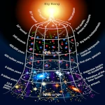
  Evolutionary Convergence: Chance, Necessity… or Mirage?
  The Five Mass Extinctions: What do these planetary catastrophes reveal?
  Cryosphere: when the ice giants still protect us
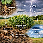 The Nitrogen Cycle: From Air to Life
  The Jet Stream: When the Atmospheric River Overflows Its Banks
 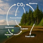 The Carbon Cycle: The Harmonious Interaction of Oceans, Forests, and Subsoils
  The Water Paradox: Without it, no life
  Why 220V Alternating Current is in Our Outlets: A Matter of Physics
  The Last Glacial Shock: The Younger Dryas and Its Impact on Prehistoric Societies
  536: The Year Without a Summer and the Beginning of the Late Antique Little Ice Age
  The Minimal Cell: The Inevitable Emergence
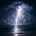
 Evolution of Global Energy Consumption: From Steam Engines to Digital Servers
 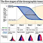 The Demographic Transition: Growth or Decline?
 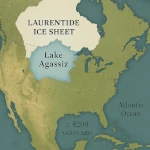 Lake Agassiz: A Deluge that Changed the Climate
 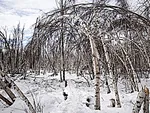 Drunken Forests: Understanding the Phenomenon of Permafrost Thaw
  There is Electricity in the Air!
  Why Doesn't CO2 Fall to the Ground?
 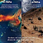 El Niño and La Niña: The Two Breaths of the Pacific That Shape Global Climate
  Endangered Species: Dynamics of Extinction
  The Toxic Legacy of Acid Rain
 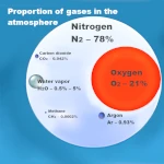 Global Warming in Figures: What the Scientific Data Says
  What is Sustainable Development?
  The Aral Sea: A Lesson for Humanity
 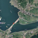 Three Gorges Dam: Impacts on Ecosystems
 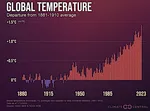 The Hottest Years Since Records Began
 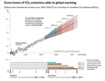 Magnitude of future global warming
  Earth in Crisis: Collapse or Renaissance?
  Ice on the Brink: The Inevitable Decline of Arctic Sea Ice
  Earth's Water Reservoirs: From Oceans to Groundwater
  Sea Levels Are Rising, But How Fast?
  The Other Climate Threat: Earth Shrouded in Shadow and Humidity
 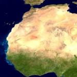 The Age of the Sahara: From Green Prairie to Stone Desert
 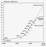 World Population from 1800 to 2100
  Oil: The Fall of a Giant in the Era of Renewable Energy
  Kamchatka King Crab: A Giant of the Oceans
  The collapse of a society
  Slight Progress in the Global Ecological Footprint
  The South Atlantic Anomaly
  The phenomenon of soil sinking is called subsidence
 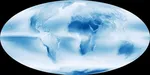 Why Is Earth So Often Cloudy?
 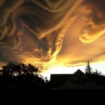 The Planet's New Clouds
 Desertec: A Solar Dream for Europe and Africa