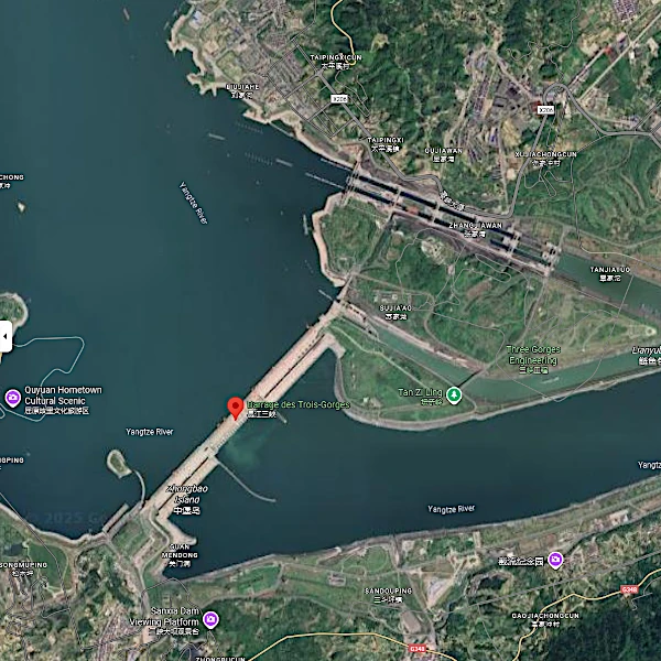
The Three Gorges Dam, on the Yangtze River in China, is the largest hydroelectric dam ever built. It is 2.3 km long and 185 m high, capable of holding a massive volume of water of about 39.3 km³. Its hydroelectric power plant can produce up to 22,500 MW, equivalent to several dozen nuclear power plants. Beyond electricity production, it regulates floods, improves river navigation, and contributes to the economic development of the region.
Its construction required the relocation of more than one million people and led to the flooding of cities, villages, and agricultural lands. The dam also influences sediment flow and water quality, altering aquatic and terrestrial ecosystems for hundreds of kilometers upstream and downstream.
The complexity of this dam lies in balancing its energy and hydrological benefits with its environmental and social impacts, which continue to be studied and monitored.
| Aspect | Impact | Affected Area | Observation / Measure |
|---|---|---|---|
| Terrestrial Habitat | Flooding and loss of riparian forests | Reservoir and adjacent areas | Reduction in biodiversity, population relocation |
| Aquatic Habitat | Fragmentation of watercourses and decline in migratory fish | Yangtze upstream and downstream of the dam | Monitoring of fish populations and migratory passes |
| Sedimentation | Accumulation in the reservoir | Main reservoir | Bathymetric measurements, occasional dredging |
| Hydrological Regime | Alteration of flow and bank erosion | Downstream river | Flow analysis and landslide monitoring |
| Gas Emissions | Methane and CO2 from decomposition of flooded biomass | Reservoir and flooded areas | Emissions monitoring and carbon balance modeling |
The Three Gorges Dam profoundly alters the natural flow of the Yangtze, creating an artificial hydrological gradient and disrupting aquatic habitats. Migratory fish species, such as the giant catfish and Yangtze catfish, have their breeding routes blocked, reducing biodiversity. Fluctuations in water levels influence the dynamics of downstream wetlands, altering the floristic and faunal composition.
Sedimentation in the reservoir leads to the formation of silt banks, which can asphyxiate benthic substrates and alter nutrient distribution. These sediments sometimes carry agricultural or industrial pollutants, increasing risks to water quality and the health of aquatic organisms.
Changes in the thermal regime and water turbidity affect the photosynthesis of algae and macrophytes, disrupting food chains. Moreover, the relative stagnation of water favors the development of invasive species and harmful algae, exacerbating ecological imbalances.
The Three Gorges Dam reservoir accumulates significant amounts of silt from the erosion of banks and Yangtze tributaries. This sedimentation alters the reservoir's capacity and can affect downstream flow, aquatic habitats, and energy efficiency. Silt also transports nutrients and pollutants, influencing water quality and the fertility of agricultural lands further down the basin.
Strategies such as flow management to promote natural sediment transport, occasional dredging, and regular monitoring are implemented to limit accumulation and its negative effects.
The Three Gorges Dam retention modifies the Yangtze's hydrological regime, reducing natural floods downstream but increasing the risk of reservoir saturation during heavy rains. This concentration of water creates significant hydrostatic pressure on the dam, requiring constant control to prevent catastrophic failures.
The accumulation of sediments in the reservoir alters the river's longitudinal profile, leading to increased erosion downstream and changes in bank morphology. Confluence areas and meanders are particularly sensitive to these changes, which can cause landslides or scouring.
Rapid variations in water level during drainage or gate opening operations generate bottom waves and strong currents, which can cause bank collapses and localized flooding. In the long term, these fluctuations can destabilize slopes and promote the occurrence of landslides on adjacent hillsides.
Finally, the concentration of water behind the dam increases the risk of induced seismicity due to pressure on the Earth's crust, a phenomenon that can affect the stability of downstream infrastructure and human habitats.
 The Principle of Least Action: Why Does Nature Always Choose the Most Economical Path?
  Evolutionary Convergence: Chance, Necessity… or Mirage?
 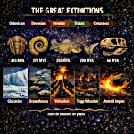 The Five Mass Extinctions: What do these planetary catastrophes reveal?
 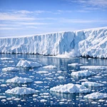 Cryosphere: when the ice giants still protect us
 The Nitrogen Cycle: From Air to Life
  The Jet Stream: When the Atmospheric River Overflows Its Banks
  The Carbon Cycle: The Harmonious Interaction of Oceans, Forests, and Subsoils
  The Water Paradox: Without it, no life
  Why 220V Alternating Current is in Our Outlets: A Matter of Physics
  The Last Glacial Shock: The Younger Dryas and Its Impact on Prehistoric Societies
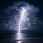

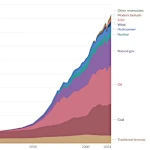 Evolution of Global Energy Consumption: From Steam Engines to Digital Servers
 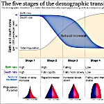 The Demographic Transition: Growth or Decline?
 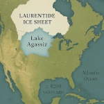 Lake Agassiz: A Deluge that Changed the Climate
  Drunken Forests: Understanding the Phenomenon of Permafrost Thaw
  There is Electricity in the Air!
  Why Doesn't CO2 Fall to the Ground?
 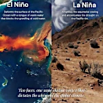 El Niño and La Niña: The Two Breaths of the Pacific That Shape Global Climate
  Endangered Species: Dynamics of Extinction
 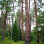 The Toxic Legacy of Acid Rain
  Global Warming in Figures: What the Scientific Data Says
  What is Sustainable Development?
 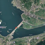 Three Gorges Dam: Impacts on Ecosystems
  The Hottest Years Since Records Began
  Magnitude of future global warming
 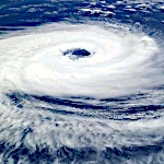 Earth in Crisis: Collapse or Renaissance?
 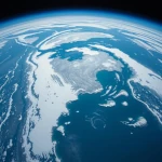 Ice on the Brink: The Inevitable Decline of Arctic Sea Ice
  Earth's Water Reservoirs: From Oceans to Groundwater
  Sea Levels Are Rising, But How Fast?
  The Other Climate Threat: Earth Shrouded in Shadow and Humidity
 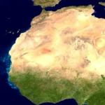 The Age of the Sahara: From Green Prairie to Stone Desert
 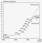 World Population from 1800 to 2100
 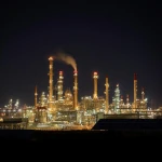 Oil: The Fall of a Giant in the Era of Renewable Energy
  Kamchatka King Crab: A Giant of the Oceans
  The collapse of a society
  Slight Progress in the Global Ecological Footprint
  The South Atlantic Anomaly
  The phenomenon of soil sinking is called subsidence
  Why Is Earth So Often Cloudy?
  The Planet's New Clouds
 Desertec: A Solar Dream for Europe and Africa