
Satellite observations and astronaut photos reveal that 67% of Earth's sky is on average covered by clouds, with a predominance over the oceans (only 10% clear sky) compared to 30% over the continents.
Satellites from NASA's EOS program (such as Terra, Aqua, and Aura) collect global data every 1-2 days, measuring cloud cover and radiative balance. However, these averages do not reflect daily variations, seasonal changes, cloud altitude, or the presence of multiple layers.
N.B.:
MODIS detects clouds better over dark surfaces (oceans, forests) than over bright surfaces (ice), and cirrus clouds are harder to identify than thick cumulus clouds.
There are three major bands where Earth's skies are often cloudy:
The first equatorial band (ITCZ) results from the collision between warm, humid air from the equator and cold air from the tropics, causing storms and clouds.
The other two bands, at 60° North and South, are caused by the clash between polar air and mid-latitude air. Conversely, between 15° and 30°, descending air inhibits cloud formation, favoring deserts.
Clouds are also observed off the west coasts (South America, Africa, North America), due to upwelling: cold water from the depths cools the humid air, forming stratocumulus clouds (the most common, covering 20% of Earth).
Mountain ranges block air currents and rain, creating deserts on the leeward side (Tibetan Plateau desert, Death Valley in California east of the Sierra Nevada, Atacama Desert in South America).
Earth is covered by 67% clouds on average, mainly due to two key phenomena:
First, massive evaporation from the oceans (which cover 71% of Earth's surface) continuously supplies the atmosphere with water vapor. This vapor condenses into clouds as it rises and cools.
Second, atmospheric movements (such as the Intertropical Convergence Zone or polar fronts) promote cloud formation by pushing warm, humid air upward, where it cools and condenses.
Satellites, like those in NASA's EOS program, confirm this dominant cloud cover, with variations depending on the region (oceans are cloudier than continents) and seasons.
 The Principle of Least Action: Why Does Nature Always Choose the Most Economical Path?
  Evolutionary Convergence: Chance, Necessity… or Mirage?
 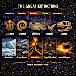 The Five Mass Extinctions: What do these planetary catastrophes reveal?
 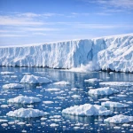 Cryosphere: when the ice giants still protect us
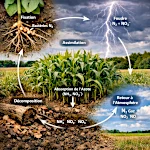 The Nitrogen Cycle: From Air to Life
  The Jet Stream: When the Atmospheric River Overflows Its Banks
 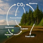 The Carbon Cycle: The Harmonious Interaction of Oceans, Forests, and Subsoils
  The Water Paradox: Without it, no life
 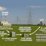 Why 220V Alternating Current is in Our Outlets: A Matter of Physics
  The Last Glacial Shock: The Younger Dryas and Its Impact on Prehistoric Societies
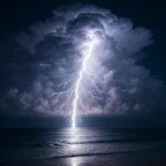
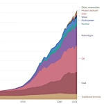 Evolution of Global Energy Consumption: From Steam Engines to Digital Servers
 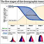 The Demographic Transition: Growth or Decline?
 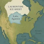 Lake Agassiz: A Deluge that Changed the Climate
 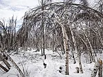 Drunken Forests: Understanding the Phenomenon of Permafrost Thaw
 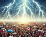 There is Electricity in the Air!
 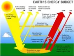 Why Doesn't CO2 Fall to the Ground?
 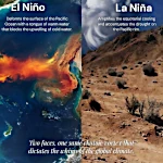 El Niño and La Niña: The Two Breaths of the Pacific That Shape Global Climate
  Endangered Species: Dynamics of Extinction
  The Toxic Legacy of Acid Rain
 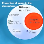 Global Warming in Figures: What the Scientific Data Says
 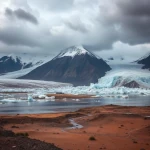 What is Sustainable Development?
 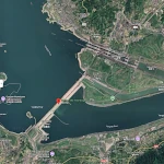 Three Gorges Dam: Impacts on Ecosystems
 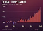 The Hottest Years Since Records Began
 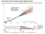 Magnitude of future global warming
 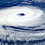 Earth in Crisis: Collapse or Renaissance?
 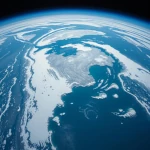 Ice on the Brink: The Inevitable Decline of Arctic Sea Ice
  Earth's Water Reservoirs: From Oceans to Groundwater
 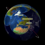 Sea Levels Are Rising, But How Fast?
  The Other Climate Threat: Earth Shrouded in Shadow and Humidity
 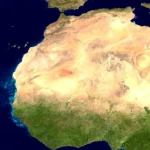 The Age of the Sahara: From Green Prairie to Stone Desert
 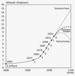 World Population from 1800 to 2100
 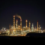 Oil: The Fall of a Giant in the Era of Renewable Energy
  Kamchatka King Crab: A Giant of the Oceans
  The collapse of a society
  Slight Progress in the Global Ecological Footprint
  The South Atlantic Anomaly
  The phenomenon of soil sinking is called subsidence
 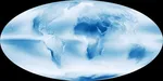 Why Is Earth So Often Cloudy?
 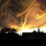 The Planet's New Clouds
 Desertec: A Solar Dream for Europe and Africa