Polynesian astronomy refers to the body of astronomical knowledge and practices developed by Oceanic peoples who colonized the vast Polynesian Triangle, stretching from Hawaii in the north to New Zealand in the southwest and Easter Island in the southeast. This astronomical tradition, passed down orally from generation to generation for over three millennia, served a vital purpose: enabling open-ocean navigation across thousands of kilometers without modern instruments.
Unlike other ancient astronomical traditions often linked to agriculture, religion, or astrology, Polynesian astronomy was primarily practical and navigational. Polynesian navigators (pwo in Carolinian, tautai in Samoan, kāhuna kaulana in Hawaiian) had to memorize the positions of hundreds of stars, their risings and settings throughout the year, and use this knowledge to maintain a precise course during voyages lasting several weeks at sea.
Polynesian astronomy cannot be understood without mentioning the vessels that enabled its practical application. The Polynesian va'a (canoes) are masterpieces of naval engineering adapted for long oceanic crossings.
The migration double canoes, used to colonize new islands, carried entire families with provisions, plants (taro, yam, breadfruit, coconut trees), animals (pigs, chickens, dogs), tools, and seeds. These "oceanic arks" had to be self-sufficient for voyages lasting several weeks.
| Culture | Period | Role and Contributions | Region |
|---|---|---|---|
| Lapita | 1600-500 BCE | First navigators, colonization of Melanesia and Western Polynesia, development of fundamental techniques | Melanesia, Western Polynesia |
| Tongans and Samoans | 1000 BCE - present | Heart of Western Polynesia, preservation of ancient navigational traditions | Tonga, Samoa |
| Tahitians and Central Polynesians | 300 BCE - present | Master navigators, colonization of the Society Islands, Tuamotu, Marquesas, base of great migrations | Central Polynesia |
| Hawaiians | 400-1200 CE | Development of a system of guiding stars, colonization of Hawaii | Hawaiian Archipelago |
| Māori | 1250-1300 CE | Last great navigators, colonization of New Zealand (Aotearoa) | New Zealand |
| Rapa Nui | 1200 CE | Colonization of Easter Island, easternmost point of the Polynesian Triangle | Easter Island |
| Micronesians | Undetermined | Development of sophisticated stellar navigation systems parallel to Polynesians | Caroline Islands, Marshall Islands |
N.B.:
The colonization of the Pacific represents one of the greatest epics in human history. Between 1600 BCE and 1300 CE, Polynesian navigators discovered and colonized thousands of islands scattered over more than 40 million km² of ocean, about 8% of the Earth's surface. They reached Hawaii (4,000 km north of Tahiti), Easter Island (4,000 km east), and New Zealand (4,000 km southwest), creating the most extensive cultural network of the pre-Columbian era.
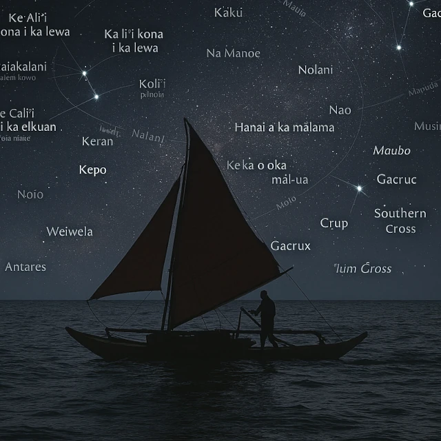
The concept of star houses or star paths is at the heart of Polynesian astronomy. Rather than dividing the sky into mythological constellations, Polynesians organized stars according to their usefulness for maritime navigation, creating a practical celestial reference system.
The Hawaiian system of star houses divided the horizon into 32 directions, each marked by the rising or setting of important stars. This "celestial compass rose" allowed navigators to maintain a precise course.
| Star | Polynesian Names | Role or Significance |
|---|---|---|
| Arcturus | Hōkūle'a (Hawaii) | Star of joy, zenithal star of Hawaii |
| Sirius | Aa (Tahiti), Ta'urua (Tahiti/Samoa) | Brightest star in the sky |
| Antares | Rehua (Māori), Lehua-kona (Hawaii) | Important southern marker |
| Southern Cross | Te Punga (Māori), Humu (Hawaii) | Crucial constellation for southern navigation |
| Pleiades | Matariki (Māori), Makali'i (Hawaii) | Marker of the Polynesian New Year |
| Orion (belt) | Tautoru (Māori), Na Kao (Hawaii) | Equatorial landmark |
| Altair | Poutu-te-rangi (Māori) | Guiding star to the north |
| Vega | Whānui (Māori) | Bright star of the southern summer |
Navigators also memorized sequences of guiding stars connecting islands. For example, to navigate from Tahiti to Hawaii, a navigator would follow different stars in succession as they rose, forming a true "celestial path."
The Southern Cross (Crux) holds a central place in Polynesian astronomy, serving as a cardinal marker equivalent to the North Star in the northern hemisphere. However, unlike Polaris, which almost exactly marks the north celestial pole, the Southern Cross requires a sighting technique to locate the south celestial pole.
The Māori called the Southern Cross Te Punga (the anchor) because it seemed to anchor the southern sky. Other names include Humu (Hawaii), meaning "to sew" or "to assemble," reflecting its characteristic shape.
The rotation of the Southern Cross around the celestial pole also served as a nocturnal clock. Navigators had memorized its positions at different hours and seasons, allowing them to estimate local time even at sea, crucial information for calculating current drift and planning watch shifts.
The Pleiades star cluster held particular importance throughout Polynesia, mainly for calendrical rather than navigational reasons. This cluster of six to seven stars visible to the naked eye served as a major temporal marker for agricultural and religious cycles.
The heliacal rising of the Pleiades (first appearance at dawn before sunrise) varied by latitude, creating New Year celebrations at different times. In New Zealand (~40°S latitude), Matariki appears in June, marking the winter solstice and the beginning of the new year. In Hawaii (~20°N latitude), Makali'i rises in November, corresponding to the Makahiki harvest and festival season.
The clarity and number of visible stars in the cluster also served as a climatic omen. A bright and distinct Matariki promised a prosperous year with good harvests, while a blurred or partially obscured cluster foretold difficulties and shortages. This belief has a meteorological basis: atmospheric clarity correlates with certain seasonal climatic conditions.
Polynesian navigators used the concept of zenithal stars to determine their latitude with remarkable precision. Each island was located under a specific star that passed directly overhead (at the zenith) at certain times of the year.
The zenithal star navigation technique worked as follows: if a navigator wanted to reach Hawaii from Tahiti (due north), he would sail north until Arcturus passed directly overhead. Knowing he was then at Hawaii's latitude, he would adjust his course east or west according to clues (presence of land birds, clouds, water color) until he found the archipelago.
The absence of writing in pre-colonial Polynesia required sophisticated methods for transmitting and memorizing astronomical knowledge. Navigators developed elaborate mnemonic systems integrating poetry, song, gesture, and symbolic objects.
Hawaiian star chants followed strict poetic structures to aid memorization while encoding precise information. For example, a chant described the sequence of guiding stars for navigating from Tahiti to Hawaii, their rising/setting positions, and the islands under their zeniths, all in a rhythmic and metric format allowing exact recitation.
The Marshallese stick charts (mattang and meddo) represent a unique form of unwritten cartography. These three-dimensional structures of palm ribs tied with coconut fibers symbolized not the topography of islands but the patterns of swells refracting around them, creating a "dynamic" map of oceanic phenomena rather than a static map of emerged lands.
| Period | Achievement | Precision or Characteristic | Region or Culture |
|---|---|---|---|
| Lapita (around 1600 BCE) | Beginning of Austronesian expansion | Coastal then open-sea navigation, colonization of Melanesia and Western Polynesia | Bismarck, Solomon, Vanuatu, Fiji |
| Around 1000 BCE | Colonization of Tonga and Samoa | Establishment of the heart of Polynesian culture, development of advanced navigational techniques | Western Polynesia |
| Around 200 BCE | Colonization of the Marquesas | First settlement of Eastern Polynesia, crossings of over 4,000 km from Samoa | Marquesas Islands |
| Around 300-600 CE | Colonization of Tahiti and the Society Islands | Establishment of the Polynesian navigation center, base for later expansions | Central Polynesia |
| Around 400-800 CE | Discovery and colonization of Hawaii | Navigation north over 4,000 km, identification of Arcturus as the zenithal star (Hōkūle'a) | Hawaiian Archipelago |
| Around 1000-1200 CE | Trans-Pacific contacts | Possible voyages between Polynesia and South America, introduction of the sweet potato (kumara) | Eastern Polynesia - America |
| Around 1200 CE | Colonization of Easter Island (Rapa Nui) | Easternmost point of the Polynesian Triangle, 3,700 km from the South American continent | Easter Island |
| Around 1250-1300 CE | Colonization of New Zealand (Aotearoa) | Last great Polynesian migration, adaptation to temperate climate, navigation by Matariki (Pleiades) | Māori culture |
| Pre-colonial | Star houses system | Division of the horizon into 32 stellar positions for precise navigation (star compass) | All of Polynesia |
| Pre-colonial | Navigation by zenithal star | Determination of latitude by observing the passage of stars at the zenith (precision ~1-2 degrees) | Polynesian open-sea navigation |
| Pre-colonial | Reading swell systems | Simultaneous identification of 4-5 swell patterns allowing orientation without celestial visibility | Micronesia, Polynesia |
| Pre-colonial | Stick charts (mattang) | Three-dimensional representation of swell patterns around islands, unique oceanic cartography | Marshall Islands, Micronesia |
| 1975-present | Navigational Renaissance (Hōkūleʻa) | Reconstruction and experimental validation of traditional techniques, successful trans-Pacific voyages | Hawaii, pan-Polynesian resurgence |
Polynesian astronomy has unique characteristics that distinguish it from other major ancient astronomical traditions, while sharing certain similarities that reveal universals of human astronomical thought.
Polynesian astronomy demonstrates that a civilization without writing, formal mathematics, or sophisticated instruments can nevertheless develop functional astronomical mastery rivaling the most advanced systems of antiquity. This achievement challenges the implicit hierarchies between cultures "with" and "without" writing, showing that cognitive complexity and practical effectiveness do not necessarily depend on these conventional markers of "advanced civilization."
 The Weak and Strong Anthropic Principles: Two Ways of Reading the Same Universe
  The Universe: Matter... or Information?
  Dark Energy: The Most Mysterious Force in the Universe
 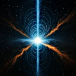 The Fountains of Creation: The Myth of White Holes
  The Great Silence: 10 Insurmountable Walls to Meeting E.T.
  The 5 Cosmic "End of the World" Scenarios (and Why They Won't Happen)
 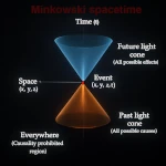 Why the Cause Always Precedes the Effect: The Order of the World is Written in This Principle
  Absolute Zero and Nothingness: Two Limits the Universe Refuses to Reach
  Economical Nature: The Secrets of Conserved Quantities
  The Incredible Precision of the Universe's Laws: Chance or Necessity?
  The Mystery of the Arrow of Time: Why Can't We Go Back?
  The Big Bang: At the Frontiers of the Model
  When Space Bends: The Tiny Slope That Guides the Universe
 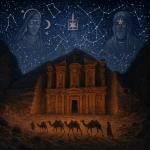 Nabataean Astronomy: Masters of the Desert Between Starry Skies and Stone Constructions
 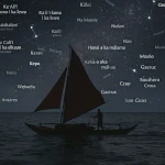 Polynesian Astronomy: The Art of Navigating the Pacific Ocean
  Mesopotamian Astronomy: The Cradle of Celestial Observation
 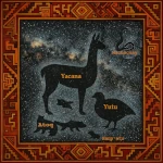 Andean Astronomy: A Sacred Link Between Sky and Earth
  Ancient Persian Astronomy: Between Babylon and the Islamic Golden Age
  Mayan Astronomy: Celestial Cycles Dictated Religious, Agricultural, and Political Time
  Islamic Astronomy: When Baghdad Illuminated the Sky of Science
  Indian Astronomy: From Sacred Poetry to Scientific Thought
  Ancient Greek Astronomy: The Universe of Philosophers in Search of Cosmic Order
  The Three Cosmic Shapes: A Hidden Geometry of the Universe
  Egyptian Astronomy: Between Sky and Nile, the Secrets of Time
  Babylonian Astronomy: When the Sky Predicted Destiny
  Chinese Imperial Astronomy: A Millennial Scientific Legacy
  Extreme Cosmic Objects: Where Physics Explodes
  Mirror Universe: Coexistence of Two Worlds in a Cosmic Reflection
  The first second of our history
 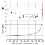 Time Dilation: Relativistic Mirage or Reality?
 Space Through Time: A Constantly Evolving Concept
 The Expanding Universe: What Does "Creating Space" Really Mean?
  From Nothingness to the Cosmos: Why Is There Something Rather Than Nothing?
  Glossary of Astronomy and Astrophysics: Key Definitions and Fundamental Concepts
 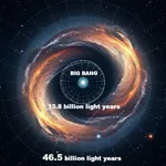 How can the Universe measure 93 billion light-years?
  How can we say that the Universe has an age?
  First Proof of the Expansion of the Universe
  Space-time slices of the observable Universe
  When the Universe Was Blind: The Long Night Before the First Stars
  Alternative theories to the accelerated expansion of the universe
  The primitive atom of Abbot Georges Lemaître
  Great walls and filaments: the great structures of the Universe
  The Origins of the Universe: A History of Cosmic Representations
  Lyman-alpha Blobs: Gaseous Traces of the First Galaxies
  Gamma-Ray Bursts: The Ultimate Breath of Giant Stars
  Perspective on the Inflation of the Universe
  The Planck Universe: the Image of the Universe Becomes Clearer
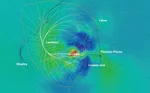 The sky is immense with Laniakea
  The Symmetries of the Universe: A Journey Between Mathematics and Physical Reality
  The Geometry of Time: Exploring the Fourth Dimension of the Universe
  How to measure distances in the Universe?
  Why ‘nothing’ is impossible: Do nothingness and emptiness exist?
  The Horizon Problem: Understanding the Uniformity of the Cosmos
  What is Dark Matter? The Invisible Force Shaping the Universe
  Metaverse, the next stage of evolution
  Multiverse: An Ocean of Expanding Space-Time Bubbles
  Cosmological Recombination: When the Universe Became Transparent
  The cosmological and physical constants of our Universe
  The Thermodynamics of the Sandpile and the Avalanche Effect
  The engine of the accelerated expansion of the Universe
 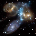 The X-Ray Universe: When Space Becomes Transparent
 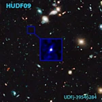 The oldest galaxies in the universe
 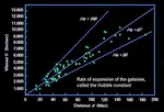 Hubble constant and expansion of the Universe
 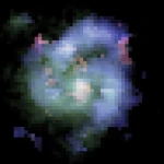 Dark Energy: When the Universe Defies Its Own Gravity
 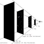 What is the Size of the Universe? Between Cosmological Horizon and Infinity
 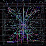 Quantum Vacuum and Virtual Particles: The Physical Reality of Nothingness
 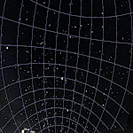 Paradox of the dark night
  Journey into the Heart of Paradoxes: The Enigmas That Revolutionized Science
  Cosmic Microwave Background: The Thermal Echo of the Big Bang