


Understanding Geostationary Orbit: Calculations and Explanations
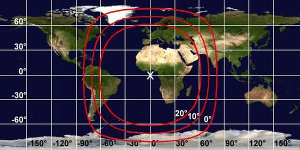
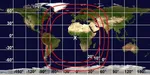
Geostationary satellites are telecommunications, broadcasting, observation, and meteorological satellites. They are located at an altitude of 35,796 km and have a fixed position relative to the Earth's surface. Their altitude allows them to "see" more than a third of the Earth; three satellites are enough to ensure almost total coverage of the Earth's surface.
What is a Geostationary Orbit?
The geostationary orbit is a circular orbit at a specific altitude above the Earth's equator, where a satellite remains fixed relative to a point on the Earth's surface. This orbit allows for a constant position in the sky, which is particularly useful for communication and meteorological satellites.
N.B.:
The geostationary orbit is a circular orbit that allows a satellite to complete one orbit around its planet while the planet completes one rotation around itself. Since its inclination relative to the Earth's equatorial plane is 0, the satellite appears "stationary," suspended in the sky always in the same position above the equator. Geostationary satellites are used for continuous observation of a specific area of the Earth.
Fundamental Physical Principles
To understand and calculate a geostationary orbit, it is essential to master certain concepts of orbital mechanics:
- Orbital Period (T): the time required for a satellite to complete one orbit around the Earth.
- Standard Gravitational Parameter (µ): the product of the gravitational constant (G) and the mass of the Earth (M).
- Altitude (h): the distance between the satellite and the Earth's surface.
Calculation of the Altitude of the Geostationary Orbit
The orbital period (T) for a geostationary orbit must match the Earth's rotation period, which is 24 hours or 86,400 seconds. Using Kepler's third law, the formula for the orbit radius (⃒a⃓) is:
\[ T = 2\pi \sqrt{\frac{a^3}{\mu}} \]
- T: orbital period (in seconds)
- a: orbit radius (distance between the Earth's center and the satellite, in meters)
- µ: standard gravitational parameter (µ = GM, approximately 3.986 × 10ⁱ⁴ m³/s² for Earth)
By isolating a, we get:
\[ a = \left( \frac{\mu T^2}{4\pi^2} \right)^{1/3} \]
For Earth, with T = 86,400 s, the calculation gives an orbit radius of 42,164 km. The satellite's altitude is obtained by subtracting the Earth's radius (6,378 km):
\[ h \approx 42,164 - 6,378 = 35,786 \, \text{km} \]
Main Applications
Geostationary orbits are used in many fields:
- Communication Satellites: for international telecommunications.
- Meteorological Satellites: real-time observation of weather conditions.
- Navigation Systems: fixed points for location.
- Security and Defense: secure military communications, surveillance, and strategic intelligence.
- Environmental Monitoring: forest fires, volcanic eruptions, atmospheric or marine pollution.
- Emergency Alert Broadcasting: broadcasting alerts in case of natural disasters, such as tsunamis, earthquakes, or hurricanes.
Differences Between Synchronous Orbit and Geostationary Orbit
All geostationary satellites are synchronous, but not all synchronous satellites are geostationary.
Synchronous Orbit
- A synchronous orbit is one where the satellite completes one revolution around its planet in exactly the same time the planet takes to complete one rotation on its axis.
- This means the satellite returns to the same relative position above a given point on the planet after each revolution.
- A synchronous orbit can be inclined (the satellite oscillates between the northern and southern hemispheres), elliptical (the satellite appears to oscillate from east to west), or non-equatorial (the satellite is not aligned with the equator).
Geostationary Orbit
A geostationary orbit is a special case of synchronous orbit that meets very specific criteria:
- The satellite must be located above the equator (inclination = 0°).
- The orbit must be circular (eccentricity = 0).
- The satellite appears totally fixed in the sky when observed from the planet's surface.
This configuration is only possible for satellites around Earth, at an altitude of ~35,786 km, which corresponds to a semi-major axis of approximately 42,164 km.
Synchronous orbit vs geostationary orbit
| Characteristic | Synchronous Orbit | Geostationary Orbit |
|---|---|---|
| Satellite position | Varies with inclination/eccentricity | Always above the equator |
| Apparent motion | Possible oscillations in the sky | Satellite fixed in the sky |
| Inclination | Can be non-equatorial | 0° (above the equator) |
| Eccentricity | Can be elliptical | 0 (circular orbit) |
| Example of use | Navigation satellites (other planets) | Telecommunications, meteorology |
 How to Spot Starlink Satellite Trains in the Sky?
  AI, the Astronomer's New Eye: From Analysis to Cosmic Prediction
  What the First Images from Perseverance Show Us: The Surface of Mars, As If We Were There
  GRAIL Twin Probes: Mapping the Moon's Hidden Interior
  Earth Under Surveillance: Observation Satellites
  March 2010: The Ring of Fire Captured by the SDO Observatory
  Positions of Space Probes in 2025
  Giants of Observation: The Largest Ground-Based Telescopes
 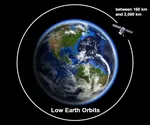 Low Earth Orbits and their uses
  Pioneer, first message to extraterrestrials!
  Infrared images: how to make them visible?
  Sputnik 1 and 2: The Dawn of the Space Age
  ENVISAT: Ten Years of Uninterrupted Observation of Earth's Ecosystems
  Lagrange Points: Gravitational Gateways of the Solar System
  Mars Reconnaissance Orbiter: The Lynx Eye Revealing Martian Secrets
  Kepler: 4,000 Worlds and More, A New Map of the Sky
  Cheops Space Telescope: A New Vision on Exoplanets
  The world of Planck
  Rosetta Space Probe: Comet Churyumov-Gerasimenko
  The Hubble Space Telescope: Three Decades of Revelations
  Première photo du télescope Hubble
  Satellites that measure underwater relief
  MESSENGER: The First Probe to Visit the Mysterious Planet
  How GPS Locates Your Position at Any Time?
  The ISS and Beyond? Towards the End of a Space Chapter
  Space Telescopes: Humanity's Eye Beyond the Atmosphere
  Space Probes: Interplanetary Travelers and Beyond
  The GAIA satellite maps the Milky Way
  How to calculate the synchronous orbit?
  E-ELT: The World's Largest Optical Telescope
  Mercury probes
  Space debris: the nightmare of operational satellites
  Aquarius: A Mission to Map Ocean Salinity
  JWST: An Unprecedented Look at the First Lights of the Universe
  METEOSAT: A Key Satellite for Climate Monitoring
  Curiosity, the first shovel, sample of Martian soil
  From Mariner to Perseverance: Successes and Failures of Mars Probes
  Where is the geostationary orbit?
  MOM, the technological demonstration
  Venus under surveillance: an overview of space probes
  What Is an Astronomical Interferometer?
  The Philae Robot and the Rosetta Comet
  Mauna Kea Under the Stars: The CFHT Telescope in Pursuit of the Universe's Mysteries