


Reading the Sky: Understanding Declination and Right Ascension
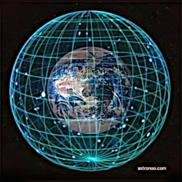
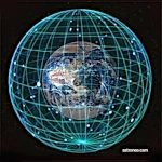
The equatorial coordinate system allows you to locate the position of a star on the celestial sphere, just as longitude and latitude do on Earth.
Right ascension (α) is measured in hours (0h to 24h) along the celestial equator, while declination (δ) is measured in degrees (−90° to +90°) on either side of that equator.
The origin of right ascension, the vernal point (0h), corresponds to the intersection between the celestial equator and the ecliptic, the apparent path of the Sun, inclined by about 23.5° (obliquity) relative to the equator.
Image source: astronoo.com (new window), AI-generated image, public domain.
Scientific abstract
The Astronoo article presents the equatorial coordinate system, the foundation of celestial cartography. Declination, the celestial analogue of latitude, measures the angle of a celestial body relative to the celestial equator, from −90° to +90°. Right ascension, the analogue of longitude, is measured in hours along the celestial equator, from 0h to 24h. These two parameters, independent of the place and time of observation, allow stars, galaxies, and planets to be located with precision. The article details their physical definition, their link to diurnal motion, and their practical use in astronomical catalogues such as Messier or NGC, as well as in planetarium software.
How do you locate a star among billions?
This article is devoted to the equatorial coordinate system, the true GPS of the sky. But how do you locate a star among billions? The answer lies in two complementary parameters. Declination, measured in degrees on either side of the celestial equator, plays the role of latitude. Right ascension, expressed in hours, minutes, and seconds, plays that of longitude. Together, they form a stable grid, independent of the place and time of observation. Unlike horizontal coordinates (azimuth and altitude), which change at every instant, equatorial coordinates remain fixed on the celestial sphere. The article details their definition, their origin (the vernal point), their link to Earth's rotation, and their use in astronomical catalogues and instruments. Thanks to these coordinates, it becomes possible to point a telescope, prepare an observation, or simply understand how astronomers map the sky. This system, used since antiquity and perfected over the centuries, remains indispensable to modern astronomy today.
Also worth exploring
Continue your exploration of the Universe with these topics:
Coordinates for locating celestial bodies
The latitude and longitude of the sky
On Earth, the position of a place is defined by its geographic coordinates: latitude and longitude. In the sky, astronomers use an equivalent system called the equatorial coordinate system, based on the projection of Earth's equator and the Greenwich meridian onto the celestial sphere. The two essential parameters of this system are declination (Dec) and right ascension (RA or \(\alpha\)). This system allows the position of a star, galaxy, or planet on the celestial vault to be specified with precision.
The celestial sphere
The celestial sphere is a geometric construction that represents the sky as a sphere centered on the observer, infinitely distant. By projecting the Earth's axes onto it, we obtain a grid of fixed celestial coordinates. Unlike horizontal coordinates (azimuth and altitude), which depend on the place and time of observation, equatorial coordinates are independent of the observer.
Declination and right ascension: physical definitions
Declination, a celestial latitude
Declination (denoted \(\delta\)) is the celestial analogue of terrestrial latitude. It measures the angle between the celestial object and the celestial equator, in the north-south plane. Expressed in degrees, minutes, and seconds of arc, it ranges from \(+90^\circ\) (at the north celestial pole) to \(-90^\circ\) (at the south celestial pole).
Right ascension, an hourly longitude
Right ascension (denoted \(\alpha\)) is the celestial analogue of longitude, but expressed in hours, minutes, and seconds, because it is linked to Earth's rotation. It is measured from the vernal point (or gamma point, where the Sun crosses the equator at the spring equinox) eastward, to the projection of the meridian passing through the object. Right ascension ranges from \(0^\mathrm{h}\) to \(24^\mathrm{h}\), i.e., a complete turn of 360°.
A universal pair of coordinates
The combination \((\alpha, \delta)\) thus allows any fixed object on the celestial sphere to be located precisely, independently of the time and place of observation, except for corrections due to the precession of the equinoxes, nutation, or atmospheric refraction for precise measurements.
Coordinates and diurnal motion
The apparent rotation of the sky
Seen from Earth, the celestial sphere appears to rotate around the axis of the celestial poles in 23h56m (a sidereal day). In this apparent motion, celestial objects move from east to west at a speed of 15° per hour, which corresponds to 1 hour of right ascension. Thus, knowledge of RA and Dec allows the exact moment when a celestial body will appear at a certain position in the sky to be predicted.
Automatic tracking by telescopes
Motorized equatorial telescopes use these coordinates to automatically track celestial objects, compensating for Earth's rotation via a motor turning at sidereal speed.
Practical use of equatorial coordinates
The following table gives some examples of equatorial coordinates of celestial objects that are easy to observe, with their type and their visibility from the northern hemisphere.
| Object | Type | Right ascension | Declination | Visibility |
|---|---|---|---|---|
| Sirius | Star | 06h 45m 09s | −16° 42′ 58″ | Southern hemisphere and low northern latitudes |
| Polaris | Star | 02h 31m 49s | +89° 15′ 51″ | Northern hemisphere, close to the celestial pole |
| M31 | Galaxy | 00h 42m 44s | +41° 16′ 09″ | Northern hemisphere, visible to the naked eye under good sky |
| M42 | Nebula | 05h 35m 17s | −05° 23′ 28″ | Visible from both hemispheres |
| Vega | Star | 18h 36m 56s | +38° 47′ 01″ | Northern hemisphere, very bright in summer |
| Alpha Centauri | Star | 14h 39m 36s | −60° 50′ 02″ | Southern hemisphere |
Astronomical catalogues
To locate a given celestial body, astronomical catalogues such as the Messier catalogue or the NGC always indicate the equatorial coordinates...
- Right ascension: \(00^\mathrm{h}42^\mathrm{m}44^\mathrm{s}\)
- Declination: \(+41^\circ16'9''\)
This means it is close to the north celestial pole, and therefore always visible from the temperate latitudes of the northern hemisphere.
Planetarium software
Software such as Stellarium or mobile applications now allow these coordinates to be entered directly to display the position of an object and point an observation instrument.
Conclusion: a universal celestial grid
A precise cartography of the sky
The equatorial coordinate system, with declination and right ascension as its fundamental axes, constitutes a stable, precise, and universal grid for mapping the sky. It allows astronomers to locate and track celestial objects with great rigor, facilitating observation, space navigation, and astrophysical research.
An accessible practice
Although abstract at first glance, these coordinates quickly become intuitive for anyone using an equatorial mount, planetarium software, or taking an interest in fundamental celestial mechanisms.
References
FAQ: Everything you need to know about declination and right ascension
What is declination in astronomy?
Declination is the angle that locates a celestial body north or south of the celestial equator. It is the celestial equivalent of terrestrial latitude. Expressed in degrees, minutes, and seconds of arc, it ranges from −90° (south celestial pole) to +90° (north celestial pole). A celestial body whose declination is close to 0° is near the celestial equator, while a declination close to +90° places it near the north celestial pole.
What is right ascension?
Right ascension is the celestial equivalent of longitude. It is measured in hours, minutes, and seconds along the celestial equator, from the vernal point to the meridian of the celestial body. A complete turn corresponds to 24 hours, i.e., 360°. This hourly unit recalls that the sky rotates by 15° per hour, which facilitates the locating and tracking of celestial bodies.
Why is right ascension measured in hours?
Right ascension is measured in hours because Earth's rotation makes the sky pass by at an apparent speed of 15° per hour. One hour of right ascension therefore corresponds to 15° of angle. This convention, inherited from ancient astronomy, simplifies calculations of position and tracking of celestial bodies, particularly for motorized equatorial telescopes.
What is the difference between equatorial and horizontal coordinates?
Horizontal coordinates (azimuth and altitude) depend on the place and time of observation: they change over the course of the night. Equatorial coordinates (declination and right ascension), on the other hand, are fixed on the celestial sphere and independent of the observer. They therefore allow a celestial body to be catalogued and found anywhere in the world, at any epoch.
What is the vernal point?
The vernal point, or gamma point, is the intersection between the celestial equator and the ecliptic, where the Sun passes from the southern hemisphere to the northern hemisphere at the spring equinox. It serves as the origin of right ascension, which is measured from this point eastward. Due to the precession of the equinoxes, the vernal point moves slowly across the celestial sphere.
How do you use these coordinates to point a telescope?
To point a telescope on an equatorial mount, simply set the right ascension and declination of the desired object, after aligning the mount on the celestial pole. Catalogues and planetarium software provide these coordinates for thousands of objects. Once the mount is calibrated, tracking is automatic thanks to the motor that compensates for Earth's rotation.
 From Black Basalt to Blue Oceans: Earth's Changing Palette
  Plate Tectonics: The Invisible Engine Moving the Continents
  The Number 360: The Mathematical Key to the Babylonian Sky
  Wet-Bulb Temperature: Humanity's Climate Time Bomb
  Why Doesn't Earth's Atmosphere Escape into Space?
  Origins of Earth: Magmatic Chaos and the Birth of the Solid World
  Earth's Atmosphere: The Invisible Shield Protecting Life
  The 5 Cosmic "End of the World" Scenarios (and Why They Won't Happen)
  Where does the water in the oceans come from? Three key stages
  From Carbon 14 to Uranium-Lead: The Science of Dating
  Major Natural Disasters: What Are the Most Likely Threats?
  The Boundary of Space: Where Does It Really Begin?
  536: The Year Without a Summer and the Beginning of the Late Antique Little Ice Age
  The leap second: scheduled end in 2035
  Planetary Alignments: A Fascinating but Relative Phenomenon
  All Deserts of the World
  Earth's Paleoclimates and Carbon Dioxide
  What is the effect of large lakes and water reservoirs on Earth's rotation?
  International Date Line
  Start Date of the Seasons: A Complex Celestial Mechanism
  Paleomagnetism: the magnetic memory of rocks
  3D Simulator: Revolutions of the Planets
  Geological Time and Mass Extinctions: From the Ordovician to the Cretaceous
  Earth History: Timeline Compressed into 24 Hours
  Earth's Water: An Extraterrestrial Origin?
  Reading the Sky: Understanding Declination and Right Ascension
  How is Earth's magnetic field born and why does it reverse?
  Earth's Magnetosphere: The Invisible Shield
  Fujita Scale: Classifying the Fury of Tornadoes
  Earth's Radioactivity: The Internal Energy of Our Planet
  The Deep Sea: Exploring the Deepest Ocean Trenches
  Why Are Days Getting Longer?
  The Depths of the Earth: From the Lithosphere to the Core
  Earth's Movements: How Earth Traces Its Spiral Through the Universe?
  How much is the sea level rising?
  The Life of Earth: Structure and Layers of the Earth
  The Eccentricity of Earth's Orbit: An Ellipse That Changes Everything
  Little Ice Age: The History of a Natural Climatic Cooling
  The Quest for Time: How Ancient Civilizations Used Astronomy?
  Van Allen Belt: A Rampart Against Cosmic Particles
  The Cosmos in Our Measure: When Man Invents the Universe
  What is the pendulum fixed relative to?
  Problem of longitude at sea
  World population, still gallopingin 2008
  The Oldest Image of Earth from Space
  Earth's Obliquity and Variations in Its Axis of Rotation
  The Astronomical Unit Fixed: A Length, No Longer an Orbit
  Water: one molecule, three states on Earth
  Simulator, the round of near-Earth cruisers
  Satellites that measure underwater relief
  Hadean's Hell
  The First Free Flight of an Astronaut in Space
  The first measurement of the Earth-Sun distance
  La The Announced End of the World on December 21, 2012: A Millennial Prophecy
 The Equinoxes: An Astronomical Event
 Milankovitch Cycles: The Astronomical Rhythm of Earth's Climate
 Why Is Earth So Often Cloudy?