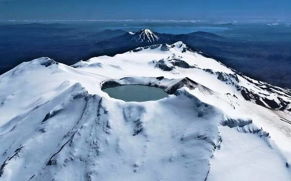
New Zealand's volcanic soils, is located on the "Ring of Fire" of the Pacific, is an alignment of terrestrial volcanoes and underwater on the oceanic trenches.
The volcanoes bordering the Pacific Ocean on the majority of its circumference, or about 40,000 miles.
This area is called "Ring of Fire".
New Zealand is a tectonic zone of the Earth's crust, it is not surprising to find dozens of volcanoes, geothermal areas and lakes that fill the calderascaldeiraPortuguese, meaning "cauldron" ) is a circular depression, a collapse at the top of some large volcanoes. The caldera is usually surrounded by high cliffs hundreds of meters high. Calderas can reach sizes of tens of kilometers in diameter, such as Lake Toba on Sumatra island (100 km × 30 km). This is called supervolcanoes. Large caldera filled with water over time and form lakes like the Toba, Crater Lake, United States or Askja in Rift is Icelandic. .
The North Island or Ile smoking is the most volcanic, this is where we will find the main volcanoes.
Taranaki mountain located in the south-west of the North Island, Mt Tongariro and Ruapehu stratovolcano located in the center of the North Island, the Ngauruhoe, in the Central Plateau of the North Island, Mt Tarawera, in the Okataina volcanic Complex, Rangitoto island in the Hauraki Gulf near Auckland, etc...
Volcanoes have many different forms, but in general they are conical mountains ending in a crater or caldera.
This is the case of volcanoes in New Zealand.
The main city built in the middle of Auckland volcanoes, is only 8 km from Rangitoto.
The capital Wellington, south of the island north on Cook Strait, is the most southerly capital and most isolated in the world.
The earthquake of 1855 was the most intense earthquake ever measured in New Zealand, with an estimated magnitude of ≈8 on the Richter scale.
Entire area of New Zealand, located on the Pacific Ring of Fire at the junction of two tectonic plates, has high seismic activity, many people frequently shaking awake. On 10 June 1986, the town of Wairoa was covered over 3 meters of ash, mud, clay and stone, in the violent eruption of Mount Tarawera.
Volcanoes | Altitude | Last eruption |
Monowai | -100 m | 2008 |
Ruapehu | 22797 m | 2007 |
Raoul | 516 m | 2006 |
Whakaari | 321 m | 2001 |
Rumble III | -140 m | 1986 |
Ngauruhoe | 2291 m | 1977 |
Okataina | 1111 m | 1973 |
Tongariro | 1968 m | 1926 |
Tarawera | 1131 m | 1886 |
Taranaki | 2518 m | 1755 |
Healy | -1150 m | 1360 |
Auckland | 260 m | 1350 |
Waiotapu | 592 m | 1180 |
Rangitoto | 260 m | 600 |
Taupo | 760 m | 181 |
Maroa | 232 m | 180 |
Kaikohe-Bay | 388 m | ≈400 |
Putauaki | 867 m | ≈−300 |
Tuhua | 338 m | ≈−4300 |
Macauley | 238 m | ≈−10000 |
Manukau | 474 m | ≈−16000 |
Rotorua | 757 m | ≈−100000 |
Tauhara | 1087 m | ≈−100000 |
NB: The sailors called the latitudes between the 40th and 50th parallel of the southern hemisphere, the "Roaring Forties", because of strong winds that circulate from west to east.
Gray volcanoes eruptions explosive emit pasty lava and ash in the form of pyroclastic flows or pyroclastic flows and volcanic plumes. The word "volcano" comes from Vulcano, Aeolian Islands one named after Vulcan, the Roman god of fire. Vulcan master reigned in the bowels burning volcanoes.
Volcanic activity in the Tongariro National Park ago began about 2 million years ago and continues today.
The volcanic activity of Mt Ruapehu eruption is intense and can occur at any time. This active volcano gray New Zealand is located in the national park, in the center of the North Island.
From time to time the volcano stirs, it rejects gas and water warms crater.
On 25 September 2007, the volcano ejected during the eruption, rocks more than two meters in diameter.
Mount Ruapehu, the highest mountain in the North Island, rises to 2797 meters above sea level, the summit crater filled with water is one of the busiest in the world. Large spectacular eruptions took place in 1995 and 1996, they covered with ash snowy flanks of the mountain and the entire surrounding area.
This is why scientists are closely monitoring its activity and maintain a constant high alert on Ruapehu as the Tongariro and White Island.
On Mount Ruapehu, above 1600 meters, the volcanic soil combines with snow and glaciers on the island alone. The walls of the summit caldera are permanently snow, making Crater Lake one of the most beautiful landscape of Tongariro National Park.
The mountain has the shape of a circular cone with steep slopes and numerous valleys incised outwash. The steep slopes of Mount Ruapehu are conducive to the formation of many waterfalls such as those Waitonga of forty meters. Despite sufficient rainfall ≈1200 mm/year, the climate is very windy, low humidity and sandy and gravelly soils have produced in the volcanic area of Taupo, a desert environment, a mixture of moraines, scree limestone and sparse vegetation , mosses, lichens and shrubs scattered.
NB: A stratovolcano is a volcanic mountain that is formed by the accumulation over the eruptions of lava and ash levels. The stratovolcano is an explosive volcanism volcano, which is characterized by very steep slopes, and the presence of a dome at the top, made of lava very viscous and filled with gas. Etna, Sicily, Kilimanjaro, Tanzania, and Merapi, on the island of Java in Indonesia, the volcano Ngauruhoe in New Zealand are examples of stratovolcanoes.
View live images via webcam volcanoes of New Zealand
The volcano Taranaki (Egmont) with its 2518 m is the second highest mountain in the north of the island and the largest stratovolcano in New Zealand.
It is located at the southwestern tip of the island from the north, near the town of New Plymouth.
This is a beautiful conical stratovolcano regular as Mount Etna in Sicily, the mountain Taranaki is formed by the superposition of repeated lava flows and pyroclastic deposits (ash, slag blocks).
This young volcano emerged from the waters, date 70 000 years ago, its avalanches of ash, runny pyroclastiques Volcanic eruptions are characterized by gassing and the issuance of silicate materials almost always more or less fluid. These may take the form of lava, they can be separated as a result of the expansion of gases, giving wide range of products that are grouped under the general term of pyroclastic rocks. and limestone boulders flowing down to the sea. We can not give a specific age in the last eruption since the volcano is too young to use radiocarbon dating. There is some uneasiness among volcanologists, seismometers and GPS receivers continuously monitor the perimeter of the volcano to measure any expansion or inclination of the volcano that would be associated with incipient collapse.
The current cone is old ≈ 10 000 years and has four lava domes on its lower slopes north and south.
NB: A stratovolcano is a volcanic mountain that is formed by the accumulation over the eruptions of lava and ash levels. The stratovolcano is an explosive volcanism volcano, which is characterized by very steep slopes, and the presence of a dome at the top, made of lava very viscous and filled with gas. Etna, Sicily, Kilimanjaro, Tanzania, and Merapi, on the island of Java in Indonesia, the volcano Ngauruhoe in New Zealand are examples of stratovolcanoes.
View live images via webcam volcanoes of New Zealand