


Chimborazo: The Highest Summit on the Planet!
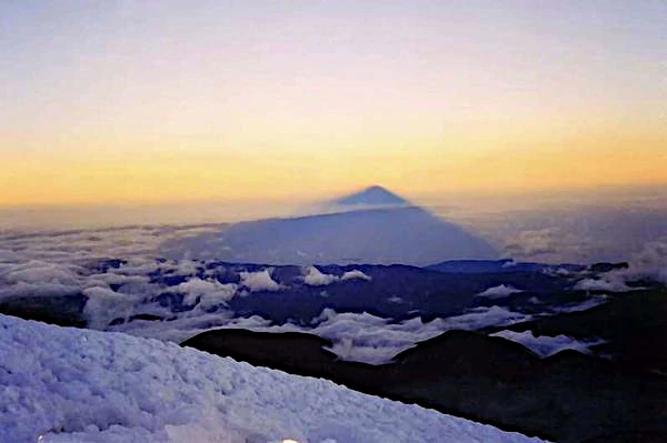
The Chimborazo (6,263 m) is the highest summit of the Ecuadorian Andes and also the highest summit on our planet, higher than Everest (8,849 m), the mountain of Tibet.
Its most fascinating peculiarity lies in its geographical position: due to the Earth's equatorial bulge, its summit is geometrically the farthest point from the center of the Earth.
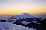
Image source: astronoo.com (new window) — AI-generated image, public domain.
Scientific summary
The Astronoo article presents Chimborazo, the highest summit on the planet when measured by distance to the center of the Earth. Although Everest is higher above sea level (8,849 m versus 6,263 m), the ellipsoidal shape of the Earth, with its equatorial bulge, places the Ecuadorian summit about 2 kilometers farther from the Earth's center. The article explores the geophysical factors that explain this peculiarity: polar flattening, centrifugal force and gravimetric altitude. It also presents a technical comparison between the two summits and the GPS measurements that validated this distinction.
Is Chimborazo really the highest summit on the planet?
This article is devoted to Chimborazo, a dormant volcano in the Ecuadorian Andes culminating at 6,263 meters. But what earns it the title of highest summit on the planet? The answer does not lie in its altitude above sea level, where Everest outdistances it by more than 2,500 meters, but in its distance to the center of the Earth. Because of the equatorial bulge, Chimborazo, located only 1° south of the equator, lies 6,384.416 km from the Earth's center, about 2 kilometers more than Everest, which is only 6,382.605 km away. This peculiarity is explained by the ellipsoidal shape of our planet, flattened at the poles, combined with the centrifugal force that lightens gravity at the equator. The article details these geophysical factors, polar flattening, measurement from the center of the Earth and gravimetric altitude, presents a technical comparison between the two summits and discusses the GPS expeditions, notably the French one in 2016, that confirmed these measurements with unprecedented precision. An essential distinction for understanding terrestrial geodesy.
Also worth exploring
Continue your exploration of the Universe with these topics:
Chimborazo: The Highest Peak on Earth
A summit farther from the center of the Earth than Everest
Chimborazo is considered the highest summit in the world based on its distance to the center of the Earth.
Although Everest is the highest summit above sea level, the ellipsoidal shape of the Earth, with a larger radius at the equator than at the poles, places the summit of Chimborazo farther from the Earth's center than that of Everest.
A difference of about 2 kilometers
Chimborazo lies 6,384.416 kilometers from the center of the Earth (measurement obtained in 2016 with a precision of ± 3 cm), while Everest is at 6,382.605 kilometers, about 2 kilometers less.
Why is Chimborazo considered the "highest" summit?
Contrary to a common misconception, the title of "highest point on Earth" can be attributed to Chimborazo (6,263 m) rather than Everest (8,849 m) according to a certain geophysical definition. This peculiarity is explained by three scientific factors:
The ellipsoidal shape of the Earth
The Earth is not a perfect sphere but an ellipsoid flattened at the poles. Its equatorial diameter (12,756 km) is larger than its polar diameter (12,714 km), creating an equatorial bulge of 42 kilometers. Chimborazo, located only 1° south of the equator, fully benefits from this protuberance.
Measurement from the center of the Earth
Measurement of altitude not from sea level but from the center of the Earth:
- Chimborazo: 6,384.416 km from the center
- Everest: 6,382.605 km from the center
This difference of 2.1 km makes Chimborazo the summit closest to the sky.
Gravimetric altitude
Due to the centrifugal force, gravity is weaker at the equator. Chimborazo therefore has a higher "gravitational altitude", meaning that an object would weigh less there than the same object on Everest, although the latter is higher relative to sea level.
Technical comparison between Chimborazo and Everest
The table below summarizes the main geodetic data that distinguish the two summits: while Everest dominates by far in altitude above sea level, Chimborazo prevails in terms of distance to the center of the Earth, owing to its near-equatorial latitude.
This peculiarity makes Chimborazo a fascinating case study in geodesy. In 2016, a French expedition confirmed these measurements using high-precision GPS technology, validating that its summit is indeed the farthest land point from the center of our planet.
| Criterion | Chimborazo | Everest |
|---|---|---|
| Altitude above sea level | 6,263 m | 8,849 m |
| Distance to the center of the Earth | 6,384.416 km | 6,382.605 km |
| Latitude | 1°S (equator) | 27°N |
History of a discovery: how did we learn that Chimborazo was the "highest"?
An old intuition, a late proof
As early as the 18th century, French scientists of the La Condamine geodesic mission (1735-1744) had noticed that the degree of latitude measured near the equator was shorter than in Europe, a sign that the Earth was flattened at the poles and bulging at the equator. Chimborazo, already known as the highest summit of the Ecuadorian Andes, then became a natural candidate for the title of farthest point from the Earth's center — but precise measurement of its position and altitude was still lacking.
Confirmation by GPS in 2016
It took the space age to settle the matter definitively. In 2016, a Franco-Ecuadorian expedition led by Jean-Mathieu Nocquet (GéoAzur / IRD) and his colleagues installed high-precision GPS receivers at the summit of Chimborazo to measure its position and altitude with centimeter precision. The result, published and confirmed by independent geodetic models, is unequivocal: the summit rises 6,384,415.98 meters from the center of the Earth, i.e. 2.1 km more than Everest. The measurement, accurate to ± 3 cm, definitively validated the geodetic supremacy of Chimborazo.
The other "highest summits" according to the chosen criterion
A question of reference
The case of Chimborazo illustrates a fundamental truth in geodesy: there is no single "highest summit", but as many records as there are measurement criteria. Depending on the chosen reference, the winner changes.
Three competing records
| Criterion | Summit | Value |
|---|---|---|
| Altitude above sea level | Everest (Himalaya) | 8,849 m |
| Distance to the center of the Earth | Chimborazo (Andes) | 6,384.416 km |
| Total height from the base | Mauna Kea (Hawaii) | ~ 10,200 m |
Mauna Kea, a Hawaiian shield volcano, rises only to 4,207 m above sea level, but its base lies about 6,000 m beneath the Pacific Ocean: its total height therefore exceeds 10,000 m, making it the tallest volcanic edifice on the planet. Thus, depending on whether one measures from sea level, from the center of the Earth or from the base of the relief, three different summits legitimately claim the title.
Key takeaways
The notion of the "highest summit" depends on the chosen reference. If one measures altitude relative to mean sea level, Everest is the highest (8,849 m versus 6,263 m). If one measures distance to the center of the Earth, Chimborazo is the highest (6,384.416 km versus 6,382.605 km), because the ellipsoidal shape of our planet — flattened at the poles and bulging at the equator — favors summits near the equator. Both statements are therefore correct, but they do not answer the same question: one compares heights above sea level, the other distances to the center of the globe.
References
- Smithsonian Institution — Global Volcanism Program: Chimborazo (No. 352071) (new window)
- Instituto Geofísico — Escuela Politécnica Nacional (Ecuador): Chimborazo (new window)
- GeoAzur / IRD — The summit of the Chimborazo volcano is still the farthest point from the center of the Earth (2016) (new window)
- La1ere.fr / AFP — The summit of an Ecuadorian volcano, the farthest point from the center of the Earth (2016) (new window)
- BBC Mundo — Chimborazo, el volcán de Ecuador más alto que el Everest (si se mide desde el centro de la Tierra) (2016) (new window)
- Barba D., Robin C., Samaniego P., Eissen J.-P. — Holocene recurrent explosive activity at Chimborazo volcano (Ecuador). Journal of Volcanology and Geothermal Research, 176: 27-35, 2008 (new window)
- Peakbagger — Volcán Chimborazo, Ecuador (new window)
- NASA Earth Observatory — Chimborazo and Tungurahua (new window)
- UNESCO — Chimborazo Fauna Production Reserve (tentative list) (new window)
- Wikipédia — Chimborazo (volcan) (new window)
FAQ: Everything you need to know about Chimborazo
What is Chimborazo?
Chimborazo is a dormant volcano located in the Ecuadorian Andes, culminating at 6,263 meters above sea level. It is the highest summit in Ecuador and the farthest point from the center of the Earth. Its snow-capped summit is visible from the city of Riobamba and is a national symbol of Ecuador.
Why is Chimborazo "higher" than Everest?
Because the notion of height depends on the reference. If one measures the distance to the center of the Earth, Chimborazo (6,384.416 km) exceeds Everest (6,382.605 km) by about 2 kilometers, due to the equatorial bulge. On the other hand, if one measures altitude relative to sea level, Everest remains the highest at 8,849 meters.
Is Chimborazo an active volcano?
Chimborazo is not considered extinct but potentially active (dormant). Recent studies have shown that it experienced at least 7 explosive eruptions during the Holocene, the last dating back to about 550 AD. With the average interval between eruptions being about 1,000 years, the volcano is statistically "overdue" on its eruptive calendar. It is under continuous monitoring by the Instituto Geofísico of Ecuador.
Can Chimborazo be climbed?
Yes, Chimborazo is a popular objective for experienced mountaineers. However, its high altitude and glacial conditions make the ascent difficult. Progressive acclimatization is essential to avoid acute mountain sickness. The most common ascent routes pass through the Carrel refuge (4,850 m) and the Whymper refuge (5,000 m). The first documented ascent was made by Edward Whymper in 1880.
What is the difference between altitude and distance to the center of the Earth?
Altitude is measured relative to mean sea level, while distance to the center of the Earth takes into account the ellipsoidal shape of our planet. A summit near the equator can be farther from the center without being the highest above sea level. This distinction is fundamental in geodesy.
How was the distance between Chimborazo and the center of the Earth measured?
Scientific expeditions, notably a Franco-Ecuadorian mission in 2016, used high-precision GPS receivers to measure the exact altitude and position of the summit. These measurements, combined with geodetic models of the Earth's shape, confirmed its record distance to the center of the Earth: 6,384,415.98 meters, with a precision of ± 3 cm. Modern geodetic satellites now allow centimeter-level precision.
 Overview of European Volcanoes: From Etna to Vesuvius
  Overview of African Volcanoes: From Kilimanjaro to Nyiragongo
  Overview of North American Volcanoes: From Mount Saint Helens to Popocatépetl
  Overview of South American Volcanoes: From Aconcagua to Cotopaxi
  Overview of Asian Volcanoes: From Fuji to Krakatoa
  Overview of Oceania's Volcanoes: From Indonesia to New Zealand
  Global Overview of Volcanoes: A World Tour of Fire Giants
  The Toba Super Eruption: Decades of Climatic Chaos
  Mauna Loa is the largest volcano in the world!
  Earth's Great Volcanoes: Red Fury, Gray Silence
  Volcanoes of Kamchatka: The Realm of Icy Volcanoes
  The Titans of Fire: Origin, Power, and Risks of Supervolcanoes
  Active Volcanoes of Colombia: Between Natural Beauty and Eruptive Risks
  New Zealand's Volcanoes: A Natural Laboratory for Plate Tectonics
  Volcanoes and the Origin of Life: When Fire and Water Spark Chemistry
  Underwater Eruptions and the Emergence of New Lands
  Volcanoes of Ecuador: Giants of Fire
  The Catastrophe of a Supervolcanic Super Eruption: Chaos and Global Consequences
  The Largest Calderas in the World: Earth's Scars
  Supervolcanoes are invisible!
  The Nevado del Ruiz volcano
  Phlegraean Fields: A volcano that really threatens Naples?
  The Yellowstone Supervolcano
  The spectacular caldera of Lake Taupo
  Chimborazo: The Highest Peak on the Planet!