A caldera (from the Portuguese "caldeira," meaning "cauldron") is a vast volcanic depression, usually circular, formed by the collapse of the roof of a magma chamber emptied after a major volcanic eruption. Unlike explosion craters, which are smaller and formed by explosive eruptions, calderas measure tens of kilometers in diameter and bear witness to cataclysmic events that have shaped the geological history of our planet.
The formation of a caldera follows a complex geological process. During a super-eruption, enormous volumes of magma (generally > 1000 km³) are expelled in a relatively short time. The partially emptied magma chamber can no longer support the weight of the overlying rocks, causing the structure to collapse and create a depression. There are mainly three types of calderas:
Our planet is home to several monumental calderas, witnesses to cataclysmic events that have shaped landscapes and influenced Earth's climate.
| Name | Location | Diameter (km) | Ejected volume (km³) | Age of formation | Type of caldera |
|---|---|---|---|---|---|
| La Garita | Colorado, USA | 35 × 75 | > 5000 | 27.8 million years | Collapse (ignimbrite) |
| Toba | Sumatra, Indonesia | 100 × 30 | 2800 | 74,000 years | Collapse (supervolcano) |
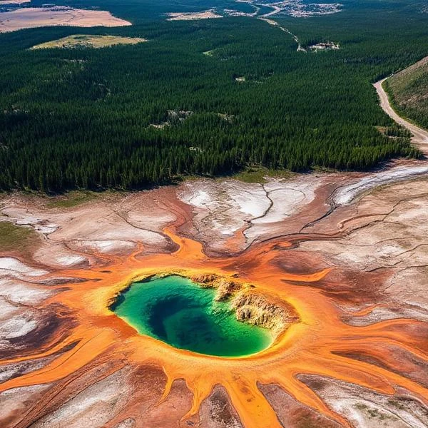
| Yellowstone | Wyoming, USA | 85 × 45 | 1000 | 640,000 years | Collapse (hotspot) |
| Taupo | North Island, New Zealand | 35 | 1200 | 26,500 years | Collapse (volcanic arc) |
| Long Valley | California, USA | 32 × 17 | 600 | 760,000 years | Collapse (volcanic complex) |
| Valle Grande | New Mexico, USA | 22 | 300 | 1.25 million years | Collapse (ignimbrite) |
| Aira | Kyushu, Japan | 20 | 400 | 22,000 years | Collapse (subduction) |
| Campi Flegrei | Naples, Italy | 13 | 500 | 39,000 years | Collapse (complex volcanic zone) |
| Santorini | Greece | 11 | 60 | 1600 BCE | Collapse (Aegean arc) |
| Krakatoa | Indonesia | 7 | 25 | 1883 | Collapse (volcanic arc) |
| Ngorongoro | Tanzania | 20 | 150 | 2.5 million years | Collapse (continental rift) |
| Cerro Galán | Argentina | 34 | 1000 | 2.2 million years | Collapse (ignimbrite) |
| Kilauea | Hawaii, USA | 4 × 3.2 | 20 | Continuously forming | Collapse (hotspot) |
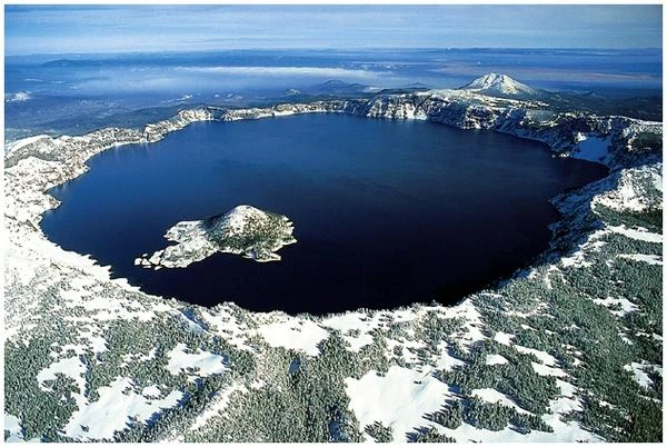
| Crater Lake | Oregon, USA | 8 × 10 | 50 | 7,700 years | Collapse (composite volcano) |
| Askja | Iceland | 8 | 45 | 1875 | Collapse (Mid-Atlantic Rift) |
| Rabaul | Papua New Guinea | 14 | 100 | 1,400 years | Collapse (volcanic arc) |
| Okataina | New Zealand | 26 | 350 | 64,000 years | Collapse (volcanic arc) |
| Valles | New Mexico, USA | 22 | 400 | 1.25 million years | Collapse (ignimbrite) |
| Ijen | Java, Indonesia | 1 | 5 | 50,000 years | Explosion (acidic) |
| Aniakchak | Alaska, USA | 10 | 50 | 3,400 years | Collapse (Aleutian arc) |
Source: Smithsonian Institution - Global Volcanism Program and United States Geological Survey.
Super-eruptions forming calderas have catastrophic consequences on a planetary scale. The injection of large amounts of ash and sulfur aerosols into the stratosphere can cause a "volcanic winter" with a significant drop in global temperatures for several years. The Toba eruption, 74,000 years ago, may have caused a global cooling of 3 to 5°C and a bottleneck in the human population, possibly reducing our species to just a few thousand individuals.
N.B.:
A volcanic winter is a temporary drop in global temperatures caused by large volcanic eruptions. Ash and sulfur gases projected into the stratosphere reflect solar light, reducing the energy received at the surface.
The large calderas on our planet are visible scars of cataclysmic events that have marked Earth's history. Studying them informs us not only about extreme geological processes but also about the fragility of our civilization in the face of natural forces. Understanding these colossal volcanic systems is essential for assessing future risks and developing mitigation strategies for eruptions that, although rare, could one day recur.
Several large calderas, such as Yellowstone, Campi Flegrei (Italy), or Aira (Japan), still host active magmatic systems. They are closely monitored by volcanologists who measure ground deformation, seismic activity, gas emissions, and thermal variations. Although the risk of a super-eruption in the short term is statistically low, its consequences would be so dramatic that the international scientific community is closely watching these "sleeping giants".
 Overview of European Volcanoes: From Etna to Vesuvius
  Overview of African Volcanoes: From Kilimanjaro to Nyiragongo
  Overview of North American Volcanoes: From Mount Saint Helens to Popocatépetl
  Overview of South American Volcanoes: From Aconcagua to Cotopaxi
  Overview of Asian Volcanoes: From Fuji to Krakatoa
  Overview of Oceania's Volcanoes: From Indonesia to New Zealand
  Global Overview of Volcanoes: A World Tour of Fire Giants
 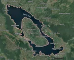 The Toba Super Eruption: Decades of Climatic Chaos
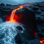
 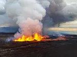 Mauna Loa is the largest volcano in the world!
 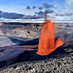 Earth's Great Volcanoes: Red Fury, Gray Silence
  Volcanoes of Kamchatka: The Realm of Icy Volcanoes
 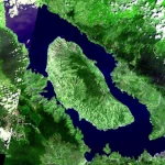 The Titans of Fire: Origin, Power, and Risks of Supervolcanoes
 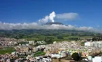 Active Volcanoes of Colombia: Between Natural Beauty and Eruptive Risks
 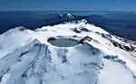 New Zealand's Volcanoes: A Natural Laboratory for Plate Tectonics
 Volcanoes and the Origin of Life: When Fire and Water Spark Chemistry
 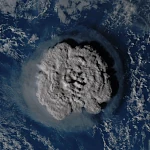 Underwater Eruptions and the Emergence of New Lands
 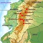 Volcanoes of Ecuador: Giants of Fire
 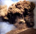 Catastrophe of a Super Eruption
 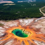 The Largest Calderas in the World: Earth's Scars
 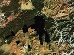 Supervolcanoes
are invisible!
Supervolcanoes
are invisible! 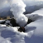 The Nevado del Ruiz volcano
 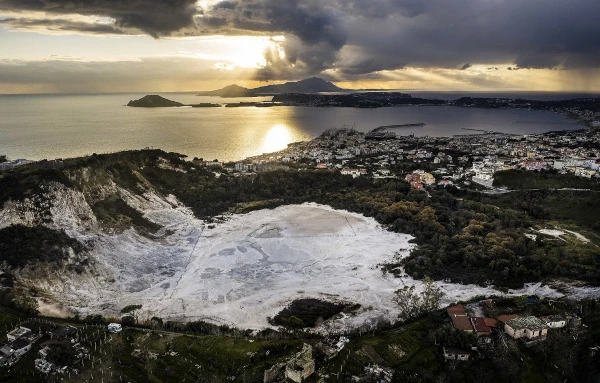 The Phlegraean
Fields
The Phlegraean
Fields 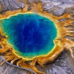 The Yellowstone
Supervolcano
The Yellowstone
Supervolcano 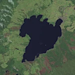 The spectacular
caldera of Lake Taupo
The spectacular
caldera of Lake Taupo  Chimborazo: The Highest Peak on the Planet!