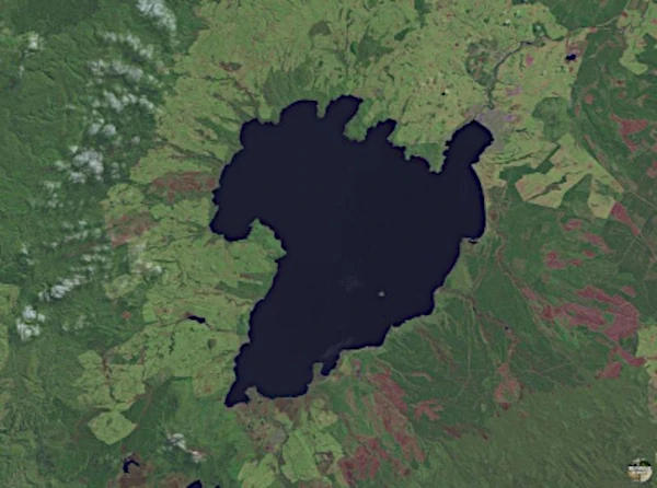
Image: Satellite view of Lake Taupo (616 km2) is a caldera surrounded by mountains, forests and volcanic valleys. Credit: public domain NASA.
Lake Taupo, located in New Zealand's North Island, is one of the country's most active and famous volcanoes. It is located in a spectacular caldera in the central region of the Taupo Volcanic Zone. It is a geological depression formed after a cataclysmic eruption of a supervolcano, the Oruanui eruption having ejected more than 1000 km3 of ash and molten rock, approximately 26500 years ago. The Taupo Volcanic Region is home to a number of spectacular craters, including the Taupo Island Crater located in the middle of the lake itself.
Lake Taupo is New Zealand's largest lake by surface area, spanning approximately 616 km2. Its deep blue waters occupy much of the caldera which is surrounded by stunning landscapes including mountains, forests and volcanic valleys.
The Lake Taupo volcano is still considered active, although it has not shown major eruptive activity for over 1800 years. During its history, it has experienced several major eruptions, the most recent of which occurred around 180 AD, forming the crater of Taupo Island. Continued seismic and geothermal activity in the area testifies to the presence of an active magmatic system beneath the volcano.
The region around Lake Taupo is known for its intense geothermal activity. There are geysers, hot springs, mud pots and fumaroles, which are the result of the interaction between hot groundwater and volcanic rocks. Popular geothermal areas near the lake include Orakei Korako, Wairakei, and Craters of the Moon.
Lake Taupo and its surroundings have great cultural significance for the Maori, the indigenous people of New Zealand. They consider the lake sacred and see a connection to their ancestors and their history. The archaeological site of Orakei Korako is also a cultural place.
There are about 1,500 active terrestrial volcanoes, of which around 60 erupt every year.