Last updated: June 01, 2013
Supervolcanoes of Our Earth
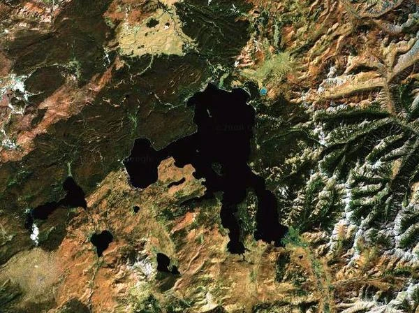
Image description: The Yellowstone supervolcano (VEI index = 8) is located in the Northwest of the United States, near the Rocky Mountains. The Yellowstone region is the result of a gigantic eruption that occurred 642,000 years ago.
Supervolcanoes are invisible!
Supervolcanoes are volcanoes capable of producing eruptions of exceptional magnitude. Supervolcanoes have a flattened structure and are difficult to detect. It is only after they have exploded, when the underground magma chamber collapses, that the famous caldera becomes visible on the ground. These calderas, several tens of kilometers in size, are so large that they can only be detected from an aerial view.
Supervolcanoes, like regular volcanoes, are located in areas of intense geological activity, including earthquakes, volcanic eruptions, or mountain formation. These areas define the boundaries between lithospheric plates (7 major plates and 20 minor ones), and volcanoes and supervolcanoes are found along tectonic zones.
The main tectonic plates define the lines of seismic activity. Among these plates are the North American, South American, Eurasian, African, Pacific, Australian, and Antarctic plates. Supervolcanoes cause super-eruptions that are unlike the typical eruptions we observe on Earth.
Humanity has not yet witnessed a super-eruption. These super-eruptions can cause considerable damage on a continental scale and have cataclysmic effects on life on Earth. The most recent recorded supervolcano explosion occurred about 26,500 years ago, at Lake Taupo in New Zealand.
The eruption of the Indonesian supervolcano on the island of Toba, about 73,000 years ago, spewed an impressive amount of ash, estimated at nearly 2,800 cubic kilometers. In comparison, the eruption of Pinatubo in the early 1990s emitted only 10 cubic kilometers of ash. The ash from Pinatubo altered Earth's albedo and lowered its average temperature by 0.6°C for two years. In 1998, Stanley Ambrose, an anthropology professor at the University of Illinois, estimated that the Toba eruption caused a global cooling of the planet for 1,800 years. Most supervolcanoes are extinct.
N.B.:
The VEI index provides a relative measure of the explosivity of volcanic eruptions. This Volcanic Explosivity Index, or VEI scale, was invented by Chris Newhall of the United States Geological Survey and Steve Self of the University of Hawaii in 1982.
List of Supervolcanoes and Their Impacts
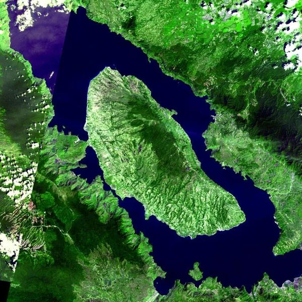
Image description: Nestled in the heart of the Sumatran equatorial forest, the Toba caldera measures 30 km wide by 100 km long. The ancient caldera is filled by a lake in the middle of which is the island of Samosir, materializing the ancient dome of the volcano.
Yellowstone Caldera (United States)
- Affected cities: Denver, Salt Lake City, Cheyenne, Boise.
- Potentially affected population: ~15 million in the immediate area, global impact on hundreds of millions.
- Climatic impact: Global cooling of 3 to 5 °C.
Phlegraean Fields (Italy)
- Main city: Naples (~3 million inhabitants).
- Potentially affected population: ~6 million in the Campania region.
- Climatic impact: Global cooling up to 2-3 °C.
Toba Caldera (Indonesia)
- Main city: Medan (~2.4 million inhabitants).
- Potentially affected population: ~10 million within a 100 km radius.
- Climatic impact: Global cooling of 3 to 5 °C (like the past eruption).
Aira Caldera (Japan)
- Main city: Kagoshima (~600,000 inhabitants).
- Potentially affected population: ~1.5 million in the region.
- Climatic impact: Regional cooling and global impact up to 1-2 °C.
Taupo Caldera (New Zealand)
- Main cities: Rotorua, Taupo (~150,000 inhabitants combined).
- Potentially affected population: ~1 million on the North Island.
- Climatic impact: Global cooling up to 3 °C.
Long Valley Caldera (United States)
- Main cities: Bishop, Mammoth Lakes (~50,000 inhabitants).
- Potentially affected population: ~1 million, including California and Las Vegas (ash fallout).
- Climatic impact: Global cooling of 1-3 °C.
Kikai Caldera (Japan)
- Main cities: Kagoshima (~600,000 inhabitants).
- Potentially affected population: ~2 million in the southern Kyushu region.
- Climatic impact: Moderate global cooling.
Rabaul Caldera (Papua New Guinea)
- Main city: Kokopo (~40,000 inhabitants).
- Potentially affected population: ~200,000 in the immediate region.
- Climatic impact: Regional and limited global cooling.
Aso Caldera (Japan)
- Main city: Kumamoto (~730,000 inhabitants).
- Potentially affected population: ~1.5 million in the Kyushu region.
- Climatic impact: Regional cooling with minor global effect.
La Garita Caldera (United States)
- Nearby cities: None.
- Potentially affected population: Local minority. Impact on the United States due to fallout.
- Climatic impact: Theoretical global cooling.
Campi Flegrei Caldera (Italy)
- Main city: Naples (~3 million inhabitants).
- Potentially affected population: ~6 million in the Campania region.
- Climatic impact: Global cooling up to 2-3 °C.
Cerro Galán Caldera (Argentina)
- Nearby cities: San Fernando del Valle de Catamarca (~200,000 inhabitants).
- Potentially affected population: ~1 million.
- Climatic impact: Moderate global cooling.
Mangakino Caldera (New Zealand)
- Main city: Rotorua (~80,000 inhabitants).
- Potentially affected population: ~1 million on the North Island.
- Climatic impact: Theoretical global cooling.
Valles Caldera (United States)
- Nearby city: Santa Fe (~85,000 inhabitants).
- Potentially affected population: ~200,000.
- Climatic impact: Limited global cooling.
Atitlán Caldera (Guatemala)
- Main city: Panajachel (~20,000 inhabitants).
- Potentially affected population: ~1 million in the altiplano region.
- Climatic impact: Moderate global cooling.
Apoyeque Caldera (Nicaragua)
- Main city: Managua (~1.3 million inhabitants).
- Potentially affected population: ~2 million in the immediate region.
- Climatic impact: Regional and limited global cooling.
Pastos Grandes Caldera (Bolivia)
- Nearby cities: Uyuni (~20,000 inhabitants).
- Potentially affected population: ~50,000.
- Climatic impact: Limited global cooling.
Corbetti Caldera (Ethiopia)
- Nearby city: Awasa (~300,000 inhabitants).
- Potentially affected population: ~1 million in the Ethiopian Great Lakes region.
- Climatic impact: Moderate global cooling.
 Overview of European Volcanoes: From Etna to Vesuvius
  Overview of African Volcanoes: From Kilimanjaro to Nyiragongo
 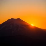 Overview of North American Volcanoes: From Mount Saint Helens to Popocatépetl
  Overview of South American Volcanoes: From Aconcagua to Cotopaxi
  Overview of Asian Volcanoes: From Fuji to Krakatoa
  Overview of Oceania's Volcanoes: From Indonesia to New Zealand
 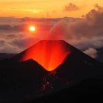 Global Overview of Volcanoes: A World Tour of Fire Giants
 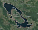 The Toba Super Eruption: Decades of Climatic Chaos
  Mauna Loa is the largest volcano in the world!
  Earth's Great Volcanoes: Red Fury, Gray Silence
  Volcanoes of Kamchatka: The Realm of Icy Volcanoes
 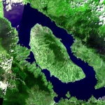 The Titans of Fire: Origin, Power, and Risks of Supervolcanoes
  Active Volcanoes of Colombia: Between Natural Beauty and Eruptive Risks
  New Zealand's Volcanoes: A Natural Laboratory for Plate Tectonics
 Volcanoes and the Origin of Life: When Fire and Water Spark Chemistry
 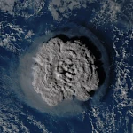 Underwater Eruptions and the Emergence of New Lands
 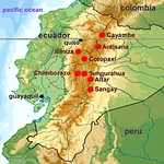 Volcanoes of Ecuador: Giants of Fire
 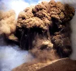 Catastrophe of a Super Eruption
  The Largest Calderas in the World: Earth's Scars
 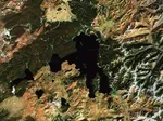 Supervolcanoes
are invisible!
Supervolcanoes
are invisible!  The Nevado del Ruiz volcano
 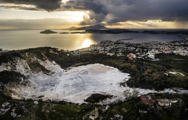 The Phlegraean
Fields
The Phlegraean
Fields  The Yellowstone
Supervolcano
The Yellowstone
Supervolcano 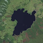 The spectacular
caldera of Lake Taupo
The spectacular
caldera of Lake Taupo  Chimborazo: The Highest Peak on the Planet!